Blog
Article List Home My Research Services Contact Me
|
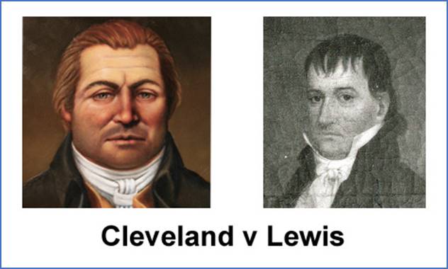
Wilkes March 17, 2022 Battle of the Roundabout I’ve always heard that Benjamin
Cleveland lost his Roundabout Plantation because someone else had a better
title to that land. I later learned
that William Terril Lewis was the one who had that better title, but
why? How was Lewis’ claim to the land
better than Cleveland’s? Now I know.
(I’m not sure about the authenticity of
these images, but they were online. We’ll
use them to visualize our challengers.) Benjamin Cleveland was one of the area’s
most colorful characters during the Revolutionary War. He was the Colonel over the Wilkes County
Regiment and fought in the pivotal Battle of Kings Mountain. He was powerful, persuasive, and stubborn. He was accustomed to getting his way. He is famously known for rounding up
British-sympathizing Tories and hanging them from the eponymous Tory Oak that
stood beside the Wilkes courthouse. He
earned the nickname “Terror of the Tories” for his unrelenting treatment of
marauders and looters. Beginning at Wilkes
County’s formation in 1777, he held several high-level government posts that
provided him the authority to make sure the county was governed in a way that
he saw fit. Much could be written about the
specific adventures of Benjamin Cleveland, but the point is that few who
challenged him were successful. He was
instrumental in building and developing the new county, and sometimes that
required strong-hand tactics that weren’t always appreciated by others. As for William Terril Lewis, he seems
to have been equally influential in neighboring Surry County. He owned thousands of acres along the
Yadkin River throughout Surry County and at least as far west as Wilkesboro. This battle for the title to Roundabout was
also a Battle of the Titans. Cleveland
and Lewis were among the wealthiest landowners in the area. North Carolina’s new land entry office opened
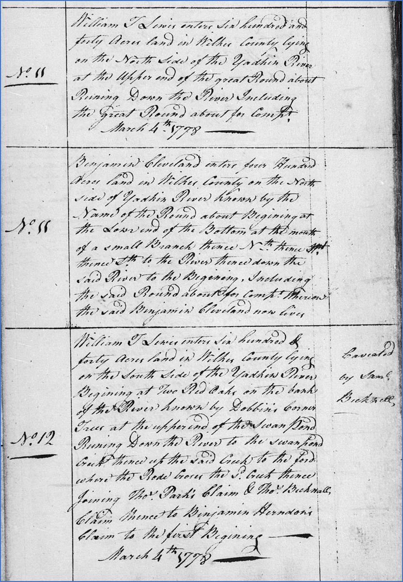
in early 1778, and on March 4th several entries, or petitions for
land, were made in Wilkes County including an entry by Benjamin Cleveland for
400 acres “on the north side of the Yadkin River known by the name of the
Roundabout”. Today this is along Hwy
268 in Ronda.
Notice that Entry #11 was the one to
Benjamin Cleveland. Immediately before
it, another Entry #11 was issued to William T. Lewis. It was similarly described as 640 acres “on
the north side of the Yadkin River ... including the great Roundabout”. How can two people be claiming the same Roundabout
land? They can’t both own it, and that’s
the problem.
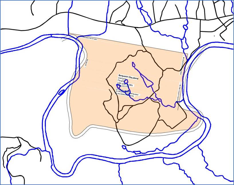
Notice that the metes and bounds that
form the Roundabout tract (shown above) are much smaller than the actual land
enclosed by the Yadkin River. I wonder
if Cleveland might have had his foot on the scale when the property was being
surveyed. If he paid the state for 348
acres when the land actually measured closer to 550 acres, he would make an
immediate profit just by submitting the paperwork. Jumping ahead to the end of the story,
it was about 1786 when the final court battle determined that Benjamin
Cleveland’s claim to Roundabout was inferior and he was forced to give it up. Even though he had acquired more than 3,000
acres in other parts of the county, Cleveland moved south to Oconee County,
SC. Maybe he found a good deal on land
there that he didn’t want to pass up.
Or, maybe he was angry about losing Roundabout, and he wanted to get
away from the “thieves” who stole his homeplace. Either way, he lived in South Carolina
until his death in 1806. And now, the rest of the story... What made it evident to the court that William
Terril Lewis had a better claim to the land?
They both entered the same land on the same day, and Cleveland’s entry
resulted in the land grant. I found the
answer in a book by A. B. Pruitt
titled “Petitions For Grant Suspensions (Part 2)”. As it turns out, Lewis had evidence of a
much earlier deed to the property. On 9/23/1778, just six months after the
land was initially entered, William T. Lewis attended the district Superior
Court to state his case. He said that “sometime”
ago he bought two tracts from Hugh Dobbins in Wilkes County on the Yadkin
River. One was the Roundabout tract,
and the other was the Swan Pond tract.
Notice on the entry book page shown above that Entry #12 is to William
T. Lewis for 640 acres on the Swan Pond.
A note in the margin says, “caveated by Sam’l Becknell”. This meant that Samuel Becknell objected to
Lewis’ entry because he had been granted the Swan Pond tract just as Cleveland
had been granted Roundabout. Now Lewis
was telling the court that the state had wrongly granted land to Cleveland
and Becknell and that he was the rightful owner of both tracts.
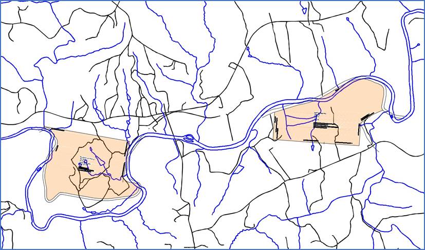
The Swan Pond tract was on the south side
of the Yadkin River about a mile and a half east of Roundabout, at the mouth
of what we now call Swan Creek. Arguing before the court, Lewis stated
that he fairly purchased the land from Hugh Dobbins who had purchased it from
Earl Granville’s Land Office. While
Lewis didn’t provide dates, Dobbins would likely have bought these two tracts
in the 1750s or early 1760s before Granville’s Land Office ceased
operations. Lewis told the court that
he heard that he would likely lose the caveat trial. He said his opponents claimed that Dobbins’
warrants and surveys were counterfeit.
To prove his case and support his claims that the documents were legitimate,
he sought the testimony of Gen. Rutherford who had been the Deputy Surveyor
for Granville’s office. He also sent
for Thomas Frohock, a representative of John Frohock (deceased), who was Granville’s
entry taker and surveyor. Lewis presented
a certified receipt showing that Dobbins had paid the entry fees, but the
jury was unconvinced. They found in
favor of Cleveland and Bicknell. Lewis “violently” suspected that the
jury was “willfully partial” to Cleveland, but he wasn’t able to provide
proof. At some point, Lewis and his
attorneys requested a new trial on the basis that the county court decision
was biased against him. During that
county trial, Cleveland’s attorneys repeatedly interrupted his own attorneys
as they explained that none of the original jurors were freeholders which was
required. Secondly, their verdict was contrary to
similar cases with similar evidence. Thirdly,
his witnesses Rutherford and Frohock were prevented from testifying, and
their original evidence of the Dobbins grant wasn’t allowed. One of Lewis’ attorneys said that he overheard
Cleveland talking with one of the justices who had decided the case, telling
him, “you behaved like a soldier”. William T. Lewis must have continued to
press the matter, eventually receiving a future court date to retry the case. In 1785, a Wilkes deed (Bk A1, p450)
between Cleveland and Joel Lewis (probably William’s brother) mentions the
pending case in the Superior Court of Law and Equity in the District of
Morgan. While Lewis won the case
against Cleveland for the Roundabout tract, it appears that he lost his case
against Becknell for the Swan Pond tract. I searched online for a record of the
Granville Grants to Henry Dobbins, but I didn’t find anything. I also searched the Rowan, Anson, and Surry
County deed books for the transaction between Dobbins and Lewis, but I didn’t
find anything there, either. It would
be nice to see the proof that Lewis presented to the court. Perhaps these documents are among the
records that have been lost to time over the past 240 years. Or another possibility is that Cleveland was
right: Lewis’s documents were counterfeit. That would mean Hugh Dobbins never officially
owned the two tracts and, therefore, he couldn’t have sold them to Lewis. We might never know the legitimacy of Lewis’
claim, but it worked. And now we know
how Benjamin Cleveland lost his Roundabout estate.
Comment below or send an email - jason@webjmd.com |