Blog
Article List Home My Research Services Contact Me
|
Wilkes January 11, 2023 Carter Falls The Elkin Valley Trails Association (EVTA)
recently led a New Year’s Day hike from Grassy Creek Vineyard to Carter
Falls. Along the way, guides pointed
out the location of the upcoming Bridge of Dreams which will span the Big
Elkin Creek just below the falls and continue the trail northward toward
Stone Mountain. I’ve had the
opportunity to help construct and improve these trails with an extremely
passionate and productive group of volunteers and leaders who are responsible
for so many great trails in the Elkin area of Wilkes and Surry Counties.
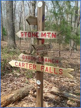
Sign
post pointing the way to Carter Falls and other destinations by the EVTA. As it always does, my mind drifts
toward wondering about the history along the Big Elkin Creek and about the
use of Carter Falls since its settlement in the late 1700s. I did some research, and I’m presenting
some of the documents that I’ve found, but this in no way is a complete
history of Carter Falls. Others will
be able to add stories that they heard from parents and grandparents about
the power generation that occurred in the early 1900s. And I know others have done their own
research and found records that I haven’t seen. My goal here is to share what I’ve found,
and hopefully it will be new and interesting to those with an interest in the
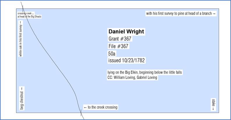
history of Carter Falls. First Owned By David Wright In 1781, Daniel Wright had 50 acres of
land surveyed “at the hed of the Big Sholes” on the Big Elkin. As shown in the survey sketch, the creek
ran north to south through the property.
1781
survey for the 50 acres that included Carter Falls and later the Carter Mill.
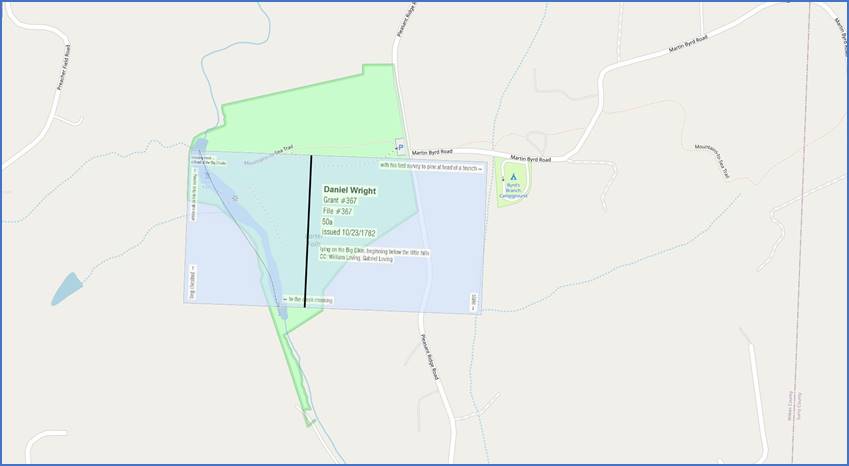
The
northwest corner of the 50-acre Carter Falls grant is at the head of the Big
Shoals.
The
50-acre grant includes the land between the Big Elkin Creek and Pleasant
Ridge Rd. (Larger
image) In the image above, the black line
dividing the 50 acres represents a division made in 1811. The western 20 acres was referred to as
“the Mill Tract” as early as 1857. I don’t know who Daniel Wright
was. He was listed in the 1787 Wilkes
census, age 21-60, with one female in the household. He’s not listed in the 1790 Wilkes census. There was a man by that name who was born
in 1759 in Fauquier County, VA. He
served as a captain in the Surry Militia during the Revolutionary War and was
at the Battle of Shallow Ford in 1780.
By the late 1780s he had moved to South Carolina, and eventually to
Alabama where he filed for his military pension. Perhaps this Revolutionary War captain was
the first owner of the falls. There’s no record of Daniel Wright
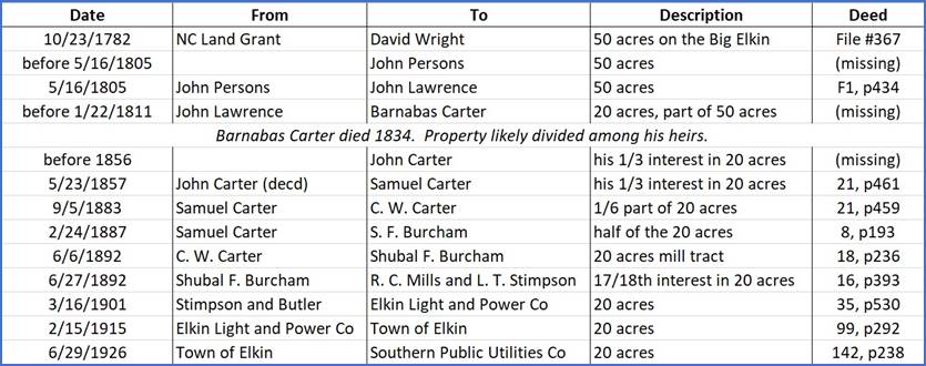
selling his land in Wilkes County, but sometime before 1805, this 50-acre
tract was acquired by John Persons. On
5/16/1805, Persons sold it to John Lawrence.
Becomes Carter’s Falls There’s another missing record before
1/22/1811 when John Lawrence sold the eastern 30 acres to Little Berry
Franklin. The western boundary of that
portion ran along the conditional line that John Lawrence had made with
Barney Carter. Unfortunately, the deed
where Barney, or Barnabas, Carter bought that 20 acres is missing, but his
acquisition of this land was the beginning of over 80 years of ownership by
the Carter family. Barnabas Carter was born about 1775,
the son of Samuel Carter and Susannah Pipes.
He married Polly Jacks in 1796, and they had several children. Instead of going into depth on their
children and the family genealogy, I’ll stay focused on the Carter Falls
property. The next land transaction
probably occurred as a result of Barnabas’ death in 1834, but again, I
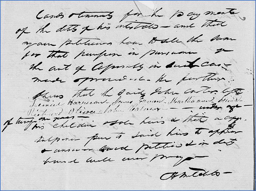
haven’t been able to find the associated deed. The next record is from May 1856 when
the estate of John Carter, deceased, was being administered. I believe this was John Carter who was born
in 1815 and who married Kendra Lewis.
Perhaps he was a son of Barnabas.
The report says that John owned land on the east side of Big Elkin
Creek, and that his widow lives there.
Additionally, he owned “an undivided one third part in a saw and grist
mill and the lot whereon it is situated on Big Elkin Creek”. This is the first time the deeds and probate
records mention a mill here. The
two-page administrator’s report is shown below.
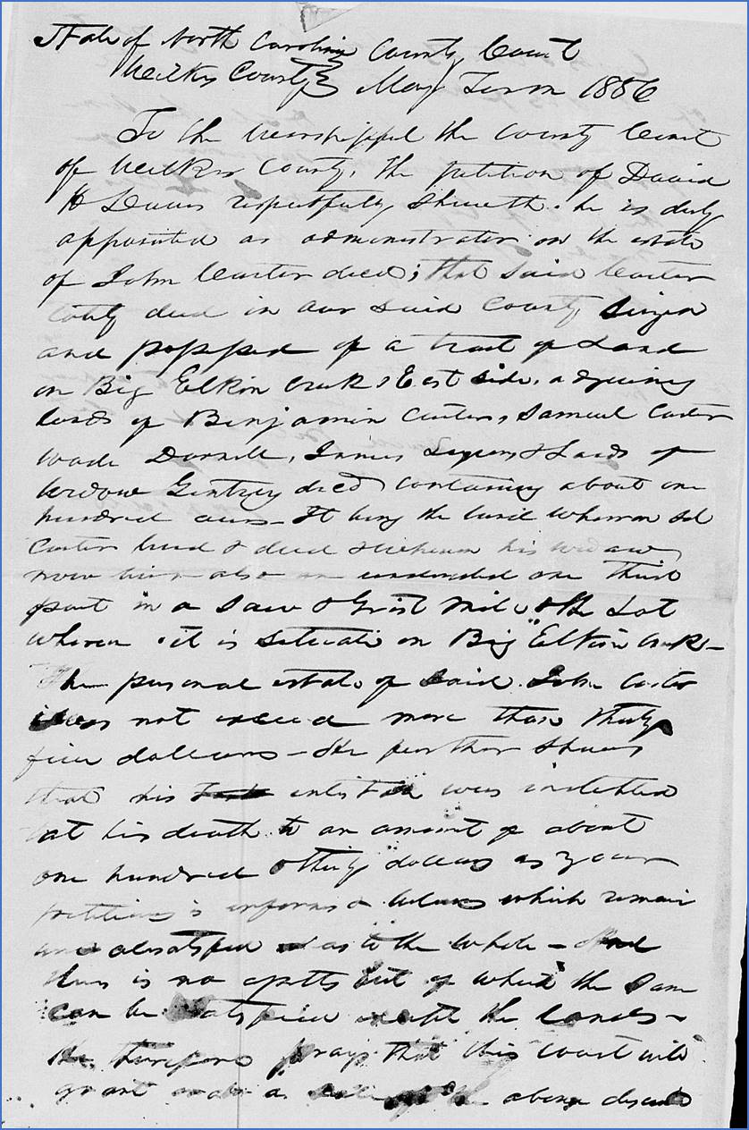
Page
1 of the administrator’s report on the estate of John Carter in May 1856
identifies his property.
Page
2 of the administrator’s report on the estate of John Carter in May 1856
lists his children. In order to cover his debts, John’s
land and household effects were sold at auction at his home on
6/10/1856. His one third interest in
the 20-acre mill and lot was sold to Samuel Carter for $86.50. The deed was recorded on 5/23/1857. This suggests that perhaps when Barnabas
Carter died in 1834, his mill tract was divided among three of his sons. I haven’t found deeds for the distribution
of the other two thirds, so we’ll follow the ownership of this one third
portion. The first of two deeds from Samuel
Carter was on 9/5/1883 when he sold his one sixth part of the 20 acres known
as the “old Carter Mill tract” to C. W. Carter. The second was on 2/24/1887 when he sold
half of the 20 acres to S. F. Burcham.
This must refer to the other half of his one third interest. In 1892, C. W. Carter had died, and the
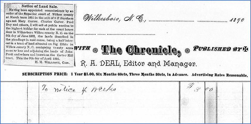
court ordered his land to be sold to pay debts. The newspaper announcement for the upcoming
auction stated that it was “a half interest” in the land known as the Carter
Mill tract. On June 6, it was
auctioned and sold to Shubal F. Burcham.
1892
notice of land sale for the Carter Mill property in The Chronicle of
Wilkesboro. Three weeks later on 6/27/1892, Shubal
F. Burcham sold his 17/18 interest in the 20-acre mill tract to R. C. Mills
and L. T. Stimpson. Stimpson and Mills
– and later Stimpson and Butler – also bought another mill that was located
less than a mile down the creek. That
mill was known as Elkin Creek Mill and later Jolly Mill. Today it is Elkin Creek Vineyard and Winery. Stimpson and Butler sold the 20-acre
mill tract to Elkin Light and Power Company on 3/16/1901. On 2/15/1915, Elkin Light and Power Co sold
it to the Town of Elkin who had purchased rights from adjoining landowners to
build a dam high enough to raise the water level by seven feet above the
present water level at the crest of Carters Falls. On 6/29/1926, the Town of Elkin sold it
to Southern Public Utilities. About
this time, Southern Public Utilities was renamed Duke Power. Below is a summary of all the deed
transactions mentioned above.
Carter
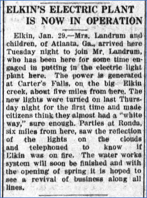
Falls was owned by the Carter family from before 1811 until 1892. Then The Lights Came Beginning in 1915 the operation at
Carter Falls was used to generate electricity to power lights in Elkin. An article from The Western-Sentinel
on February 2, 1915, sets the scene for the night when the lights came
on. That must have been quite a sight!
The
Western-Sentinel of Winston Salem on February 2, 1915. From memory, I’ve been told that the power
plant was in operation until the 1960s when flooding rain washed out a
portion of the wooden flume that carried water from the top of the falls to
the electricity-producing dynamo at the power plant.
The
wooden flume at the head of Carter Falls, early 1900s. Part
of the Elkin Historical Collection. (Larger image)
The
upper cascade at Carter Falls, 1911.
Part of the Elkin Historical Collection. Now, with the EVTA trails providing
access to Carter Falls, everyone can enjoy and appreciate this part of our
area’s history and natural beauty.
Comment below or send an
email - jason@webjmd.com |
