Blog
Article List Home My Research Services Contact Me
|
Wilkes January 29, 2023 Settling The Yadkin –
Daniel Boone Was Here A group of seven Moravians led by
Joseph Spangenburg left Pennsylvania in August 1752 in search of 100,000
acres of vacant land on which to make a new settlement. Upon arriving in North Carolina, they
became frustrated and disheartened to find that there was no reliable map of
the colony showing what land was available.
As a harbinger of things to come, on September 12, Spangenburg wrote
in his diary, “Land matters in North
Carolina are also in unbelievable confusion, and I do not see how endless
law-suits are to be avoided. A man
settles on a piece of land and does a good deal of work on it, then another
comes and drives him out, -- and who is to definitely settle the matter?” Truer words were never spoken. That’s exactly what would happen 40 years
later.
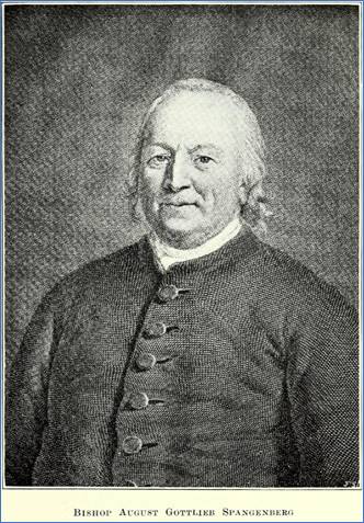
August
Gottlieb “Joseph” Spangenberg (1704-1792) was a leader among the Moravian
settlements. Making the best of a bad situation, the
Moravian team decided to make their own surveys as they searched for suitable
land at the far western edges of the colony against the “Blue Mountains”
where very little land had already been claimed. This would avoid any confusion regarding
what land was actually available. In
November 1752 they reached the Catawba River where they met John
Perkins. Along with two other Carolina
men, Spangenburg wrote that he particularly recommended John Perkins if they
needed help in the future. “(He) is intelligent, best
acquainted with the forest, industrious, a successful hunter, and I think
fond of the Brethren. I suggest using
these men because at this time practically no one lives in these parts, and
no one else will know our tracts and their boundaries except the Brethren who
are in our company, and they will quickly forget the forests, which are as
trackless as the ocean.” On November 29, 1752, while on Little
River of the Catawba, Spangenburg wrote, “We are here in a region
that has perhaps been seldom visited since the creation of the world. We are some 70 or 80 miles from the last settlement
in North Carolina, and have come over terrible mountains, and often through
very dangerous ways.” On December 14, 1752, they made camp on
the “Atkin Waters” at a place they described as being where a north and a
south branch unite. (They considered
Lewis Fork as being the north fork of the Yadkin River.) Here they made their first survey. Six days later, they camped four miles down
the river opposite the Mulberry Fields and camped near the small hut of a
Welsh man named Owens who had arrived in the spring. Mr. Owens was living on the Mulberry Fields
tract owned by Morgan Bryant. It was
here that the Moravians made a second survey. Before leaving, Mr. Spangenburg wrote in
his diary that they were 60 miles from any house, except for that of Mr.
Owens.
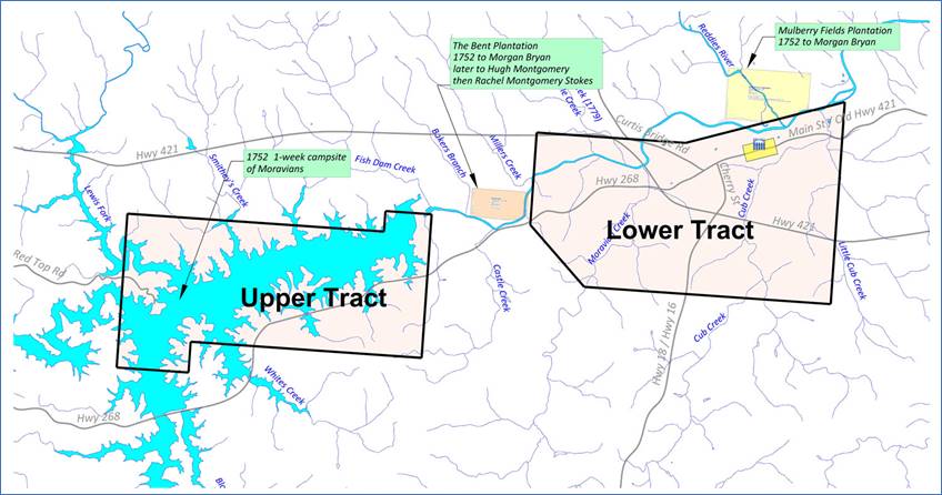
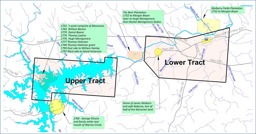
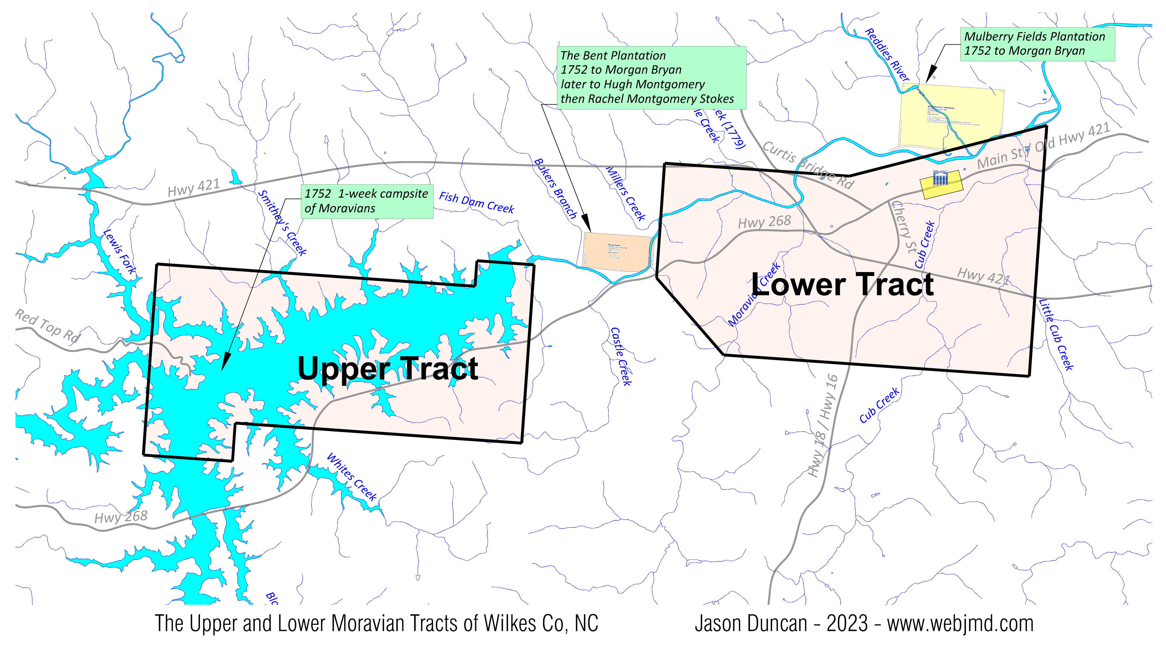
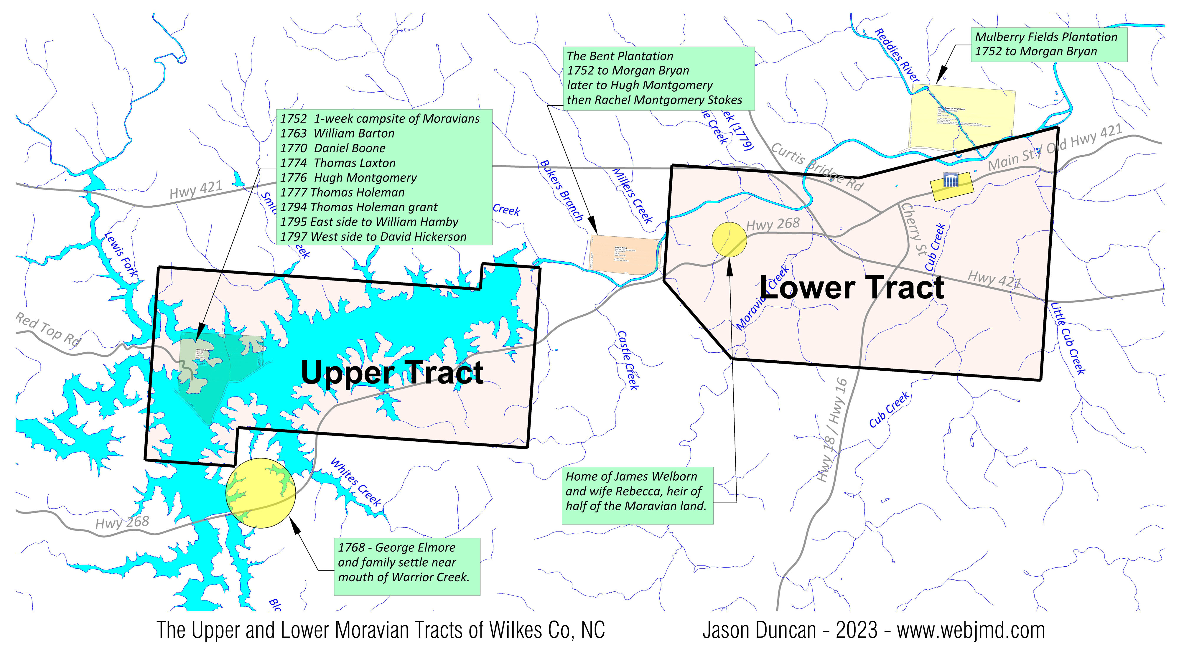
The
Moravian’s camped at the mouth of Lewis Fork in December 1752, above Morgan
Bryan’s two tracts. I wanted to provide this back story to
illustrate just how remote the Moravians found this area to be in 1752. The set of books titled Records
of the Moravians in North Carolina is much more interesting to read than
the title suggests! Volume 1 covers
the years 1752 through 1771, and it’s available online at the link
above. The account of their
exploration of North Carolina begins on page 26. Their accounts of the challenges associated
with establishing their Wachovia settlement would make a great movie! Court Is In Session Now we’ll move forward by four decades
and continue with the court case involving the disputed lands that were
granted to the Moravians as a result of their 1752 surveys. This is Part 2 in the “Settling the Yadkin”
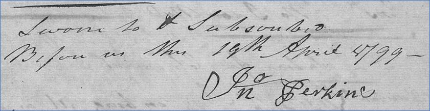
series. Part 1 can be found here. Forty-seven years after helping the
Moravians with their first surveys, John Perkins gave his deposition on April
19, 1799, at the home of James Welborn.
His home was located on the south side of the Yadkin River near River
St, perhaps on the north end of Wilkes Community College. Perkins was the chain carrier whom
Spangenburg had praised in his diary.
Perkins said that he was living at “Sherolds ford on Catawba River” in
1752 when the Moravians approached him.
Mr. Spangenburg and Mr. Antes requested that he show them some large
bodies of vacant land on the Catawba River and to assist them as a chain
carrier as they made their surveys.
They made surveys on the Little River, the main Catawba River, and
then on Johns River. They then asked if
he would take them over to the Yadkin.
By mistake, he took them north to the Three Forks of New River. Once they realized the error, they proceeded
east and eventually pitched camp near the mouth of Reddies River on the north
side of the Yadkin River. There, the
Moravians made the two surveys now known as the Upper Tract and the Lower
Tract.
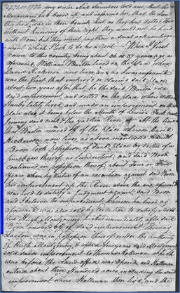
John
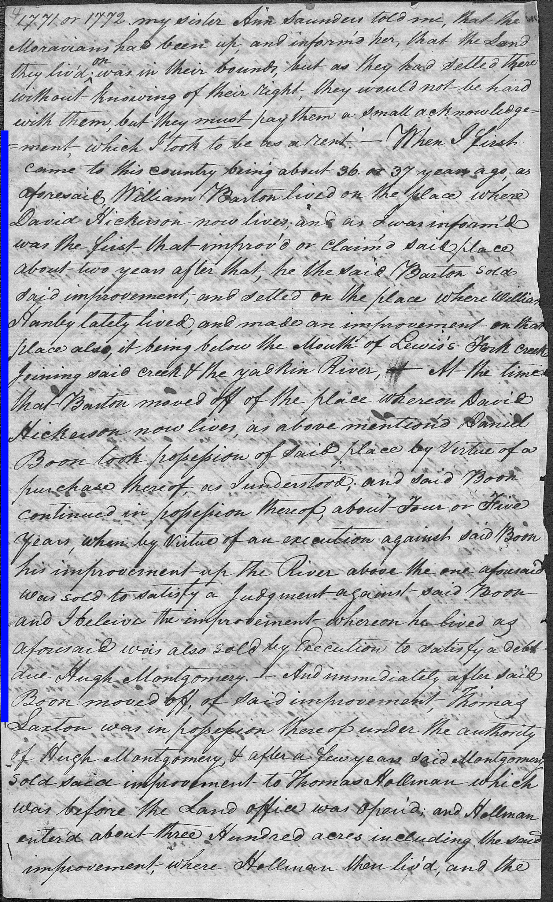
Perkins signed his deposition on April 19, 1799. In the Words of George Elmore George Elmore was called to the
courthouse for his deposition on June 28, 1805. He said he arrived here with his father 36
or 37 years ago when he was 18 year old.
Doing the math, that means he was born about 1750 and arrived here in
1768. The family settled three
quarters of a mile from the mouth of Warrior Creek near the southwest corner
of the Upper Moravian Tract. At the time he arrived, a man named William
Barton was living at the mouth of Lewis Fork on the west side. Two years later (i.e. 1770), Barton moved
to the other side of Lewis Fork, and he sold his old place to Daniel Boone
who “continued in possession thereof about four or five years.” He goes on to say that a court order
against Boone caused him to lose his improvement up the river, above the one
on Lewis Fork. He believes that Boone
also sold his Lewis Fork improvement by a court order to satisfy a debt to
Hugh Montgomery.
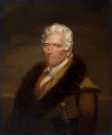
Daniel
Boone painting by Chester Harding in 1820. George Elmore is telling us that Daniel
Boone lived at the mouth of Lewis Fork from about 1770 to 1774. During that time, he also owned an
improvement further up the river. Somehow he lost both in court. I’ve heard that Daniel Boone once lived at
the mouth of Beaver Creek (4 miles up the Yadkin River) and also at a place that
was another 2.5 miles further up the river.
Perhaps George Elmore was referring to one of those locations. I’d like to learn more about Daniel Boone’s
court case, but that’s a story for another time.
This
page from George Elmore’s deposition refers to Daniel Boone. (Larger
image) It's worth remembering that Morgan
Bryan was the grandfather of Daniel Boone’s wife Rebecca. Morgan Bryan was mentioned in John Perkins’
deposition as owning the Mulberry Fields tract. He also owned the nearby Bent
Plantation. Both tracts had been
issued to Morgan only months before the Moravians made their adjoining
surveys. But by 1770, when 35-year-old
Daniel Boone was living at Lewis Fork, both of those tracts had been sold and
no longer belong to the Bryan family. According to George Elmore, when Daniel
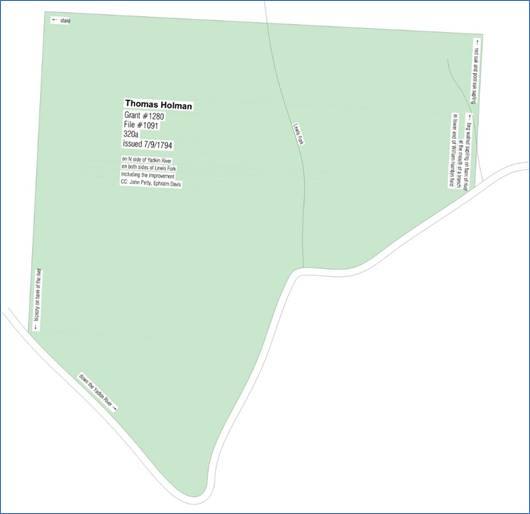
Boone lost his land on Lewis Fork, it was bought by Thomas Laxton. It then passed to Hugh Montgomery who sold
it to Thomas Holeman in 1777. Holeman
entered and received a grant for 320 acres here in 1794, but he surely knew
that this land was part of the Moravian claim and that there was a risk of
losing it.
Thomas
Holeman’s 320-acre grant at the mouth of Lewis Fork in 1794. Holeman didn’t keep this land for
long. A year later he sold the eastern
80 acres to William Hamby who was already living there (DB B1, p518). In 1797 Holeman sold the western 240 acres
to David Hickerson (DB D, p430).
Hickerson was still living there in 1805 at the time of the
deposition. Lewis Fork was the
dividing line.
The
320-acre grant to Thomas Holeman is at the west end of the Upper Tract. (Larger image) The location where the Yadkin River was
forded at Lewis Fork was called Holman’s Ford, undoubtedly because that’s
where Thomas Holeman had lived. This is
also where the assault at Fort Hamby occurred in 1865 perhaps involving
descendants of William Hamby who bought the 80 acres here in 1795. Today, most of this original 320-acre tract
is under the water of Kerr Scott Reservoir.
Comment below or send an
email - jason@webjmd.com |