Blog
Article List Home My Research Services Contact Me
|
Wilkes March 30, 2023 Boones on Beaver Creek I’ve recently had the opportunity to
spend time with a group of Daniel Boone enthusiasts who are searching for information
about the site of one of his cabins in Wilkes County. Last weekend, Mary Bohlen with the North Carolina Daniel Boone Heritage
Trail coordinated the gathering of more than a dozen people near the
mouth of Beaver Creek in the western part of the county at a spot where Daniel
Boone is thought to have had a cabin. It
was an impressive collection of knowledge and enthusiasm! By the end of the day, ground
penetrating radar identified a line 25 feet long that could represent the
edge of a cabin. The data will be
analyzed, and more testing will be done at the site at a later time.
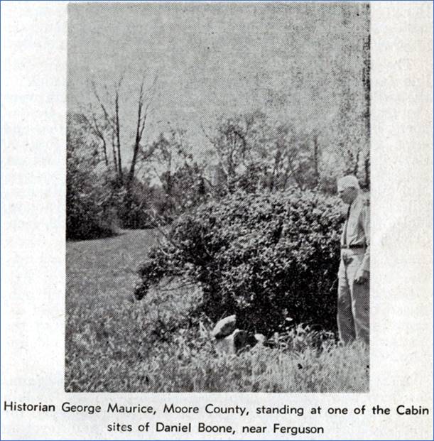
Page 23 of the book Home on the
Yadkin, printed in the 1950s. The photo above shows the site in
question during the 1950s. The bush
and stones are no longer present, making it more difficult to know the exact
spot to search. I went to the county
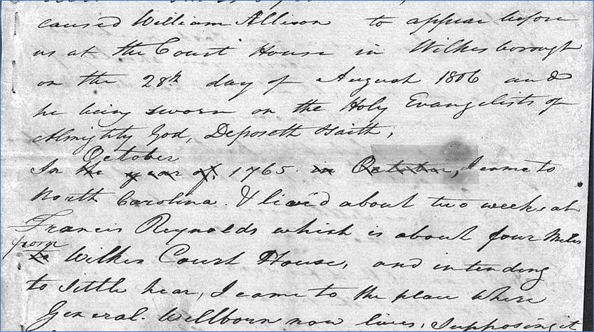
records to see if they revealed any additional clues. William Allison’s Deposition I found something in the records of the
Moravian land dispute. On August 28,
1806, William Allison gave his deposition in which he remembered events from
forty years earlier. He said that he
arrived in North Carolina in October 1765, and he stayed two weeks with
Francis Reynolds who lived four miles east of the Wilkesboro courthouse. (At that time, there was no courthouse and
no town of Wilkesboro yet.) He had
planned to settle on the vacant land near where the courthouse was later
built, but he soon discovered that it was claimed by the Moravians. To avoid any potential controversy over
future ownership of the land, he opted to settle a few miles further west,
off of the Moravian land, on the south side of the Yadkin River along Beaver
Creek.
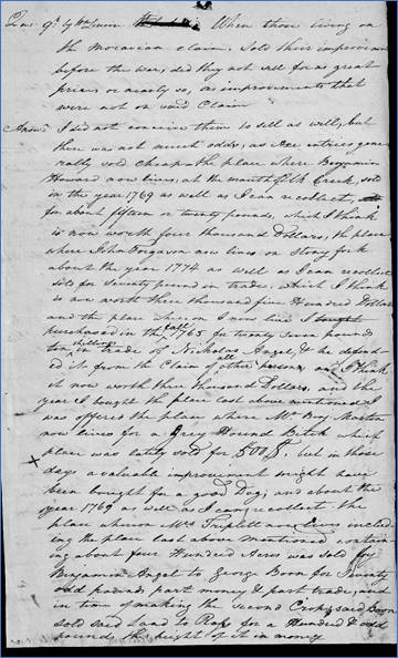
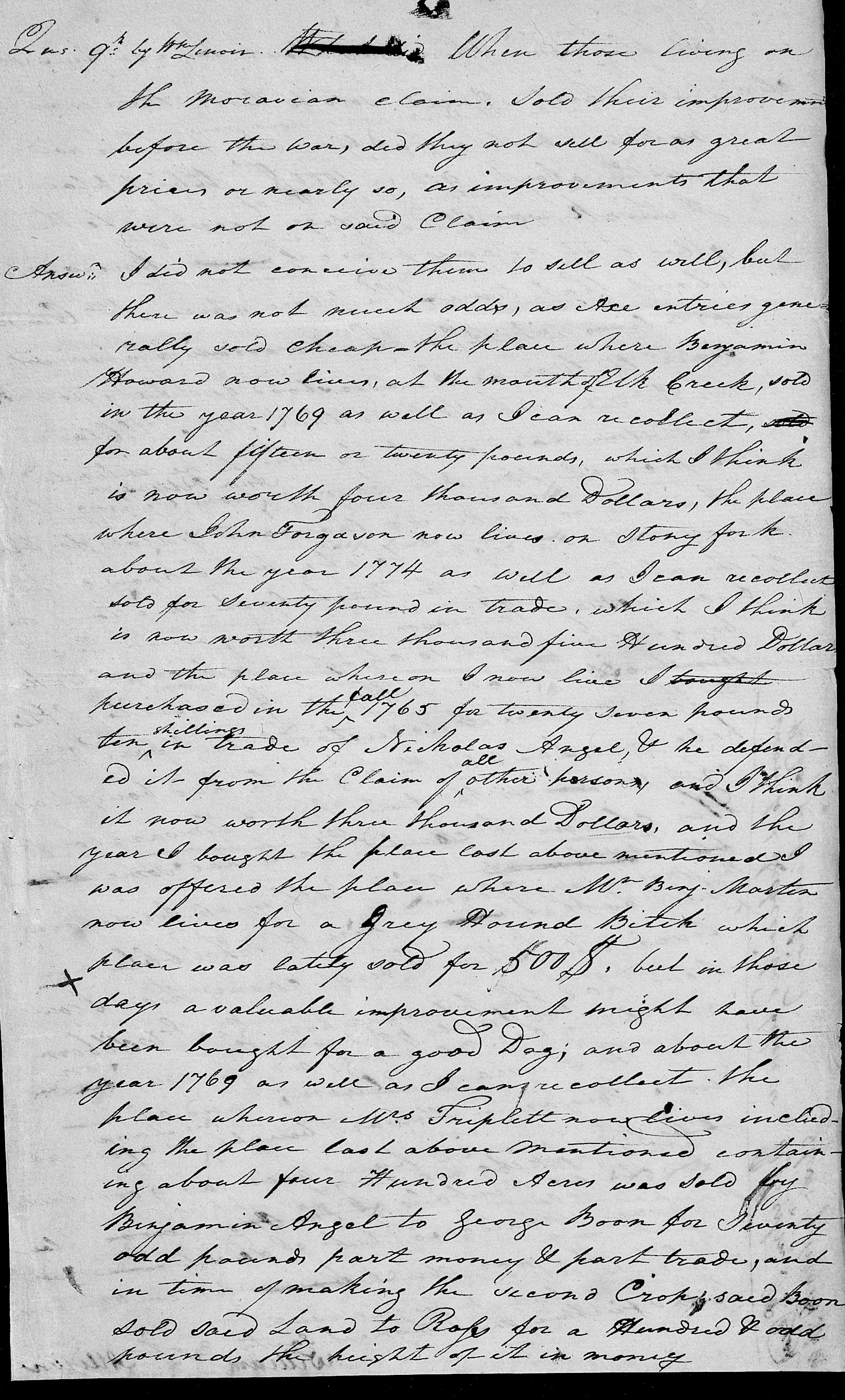
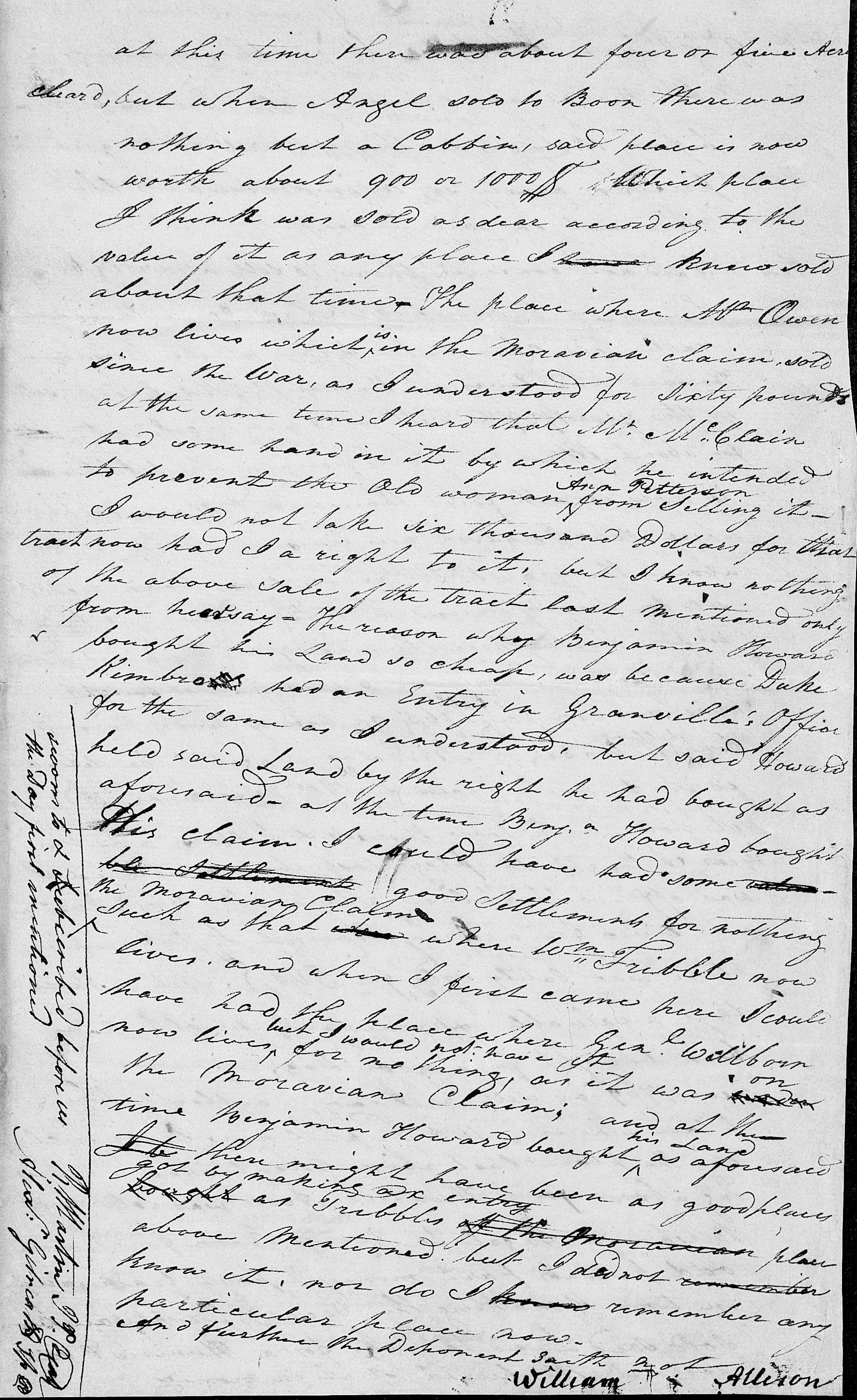
Part of the first page of William Allison’s
deposition. The Moravian case files are available
on FamilySearch. William Allison’s
deposition begins at image
542. It continues through image
549. Allison said that he purchased his
place in the Fall of 1765 from Nicholas Angel for £27, 10 shillings in
trade. He still lived in the same
place in 1806, and he estimated that the value of his land had increased to
$3,000. He said that in 1769, the place where
Mrs. Triplett now lives containing about 400 acres was sold by Benjamin Angel
to George Boone for £70, part money and part trade. At that time there was only a cabin. “And in time of making the second crop,
said Boon sold said land to Ross” for about £100, mostly in money. When Boone sold it, there were about four
or five acres cleared.
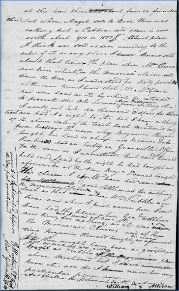
Two pages from William Allison’s
deposition (image 548
and image 549). I also made a transcription of these
two pages. William Allison’s deposition shows that
George Boone lived near him on land that was owned by Mrs. Triplett in
1806. So where did William Allison and
Mrs. Triplett live? Let’s see what the
land records show. Wilkes Deeds on Beaver Creek The first Wilkes County deeds and land
grants were issued in 1778. William Allison
waited until 1790 to get a warrant for the land on Beaver Creek that he had
been living on since 1765. The mouth
of Beaver Creek isn’t as clearly defined as many other creeks and
rivers. While the creek’s headwaters
begin eight miles away on the slopes of the Brushy Mountains, the last mile
as it approaches the Yadkin River is often two or three branches that run
parallel to each other. The bottomland
near the river is very flat, and the branches of Beaver Creek run around the
edges of fields. I wonder how farming
and cultivation over the past 250 years has changed the path of the creek in
this area. Also, the construction of
Kerr Scott Dam seven miles downstream in the 1960s must have affected the
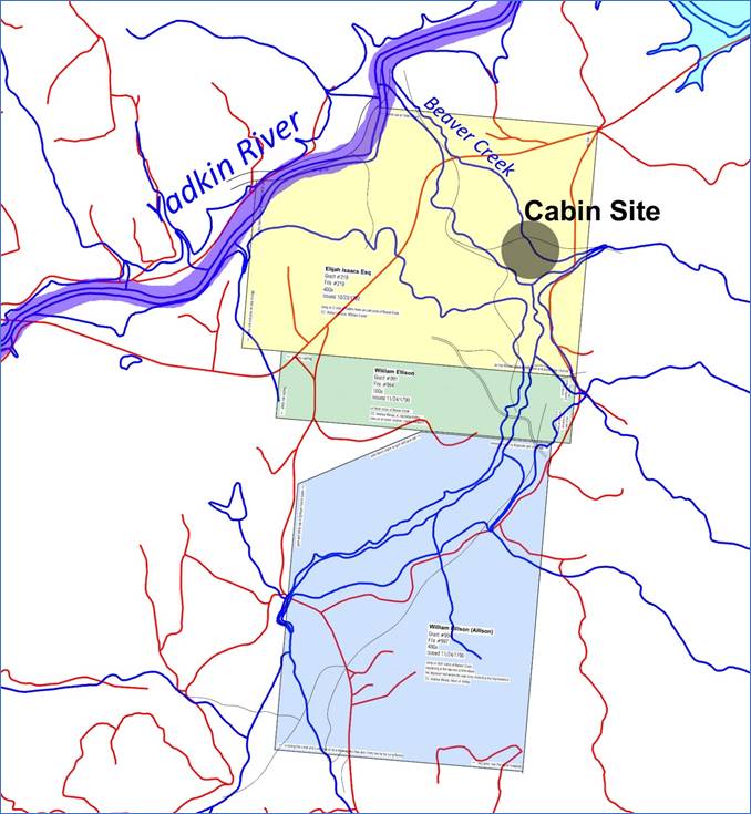
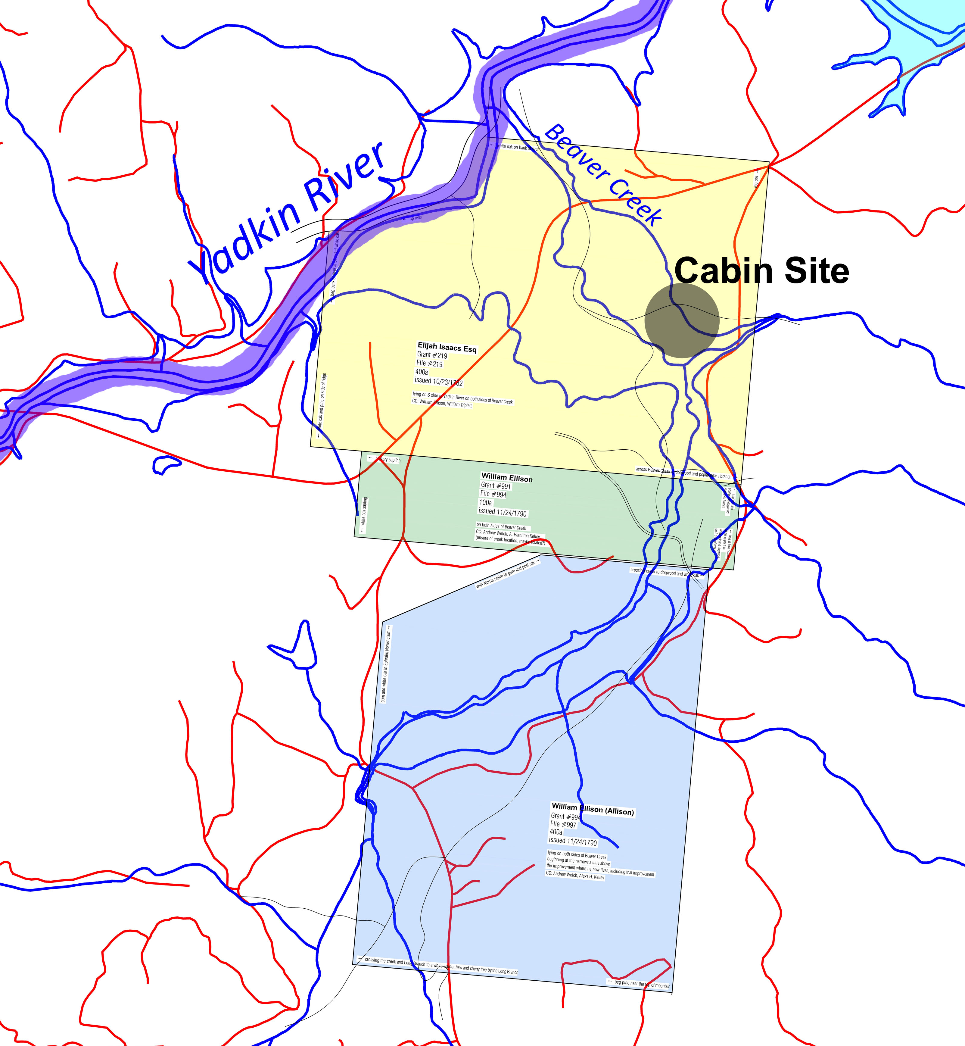
mouth of Beaver Creek in some way. The site of the Boone cabin is located
among these parallel branches of Beaver Creek about a half mile away from the
Yadkin River. It is on the eastern
portion of an original land grant of 400 acres issued to Elijah Isaacs in
1782. This tract is shown in yellow
below. On the south side of that grant
are two grants issued to William Allison/Ellison in 1790.
The cabin site is located on the old
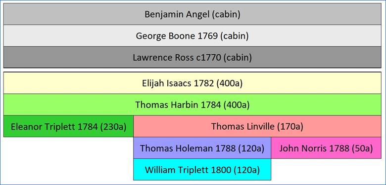
Elijah Isaacs grant. (Larger version) Elijah Isaacs sold his 400 acre tract
to Thomas Harbin in 1784. Thomas Harbin sold the northwest 230
acres to “Elenor Triplett” a few months later. She was Eleanor Harbin Triplett, widow of
William Triplett who had died during the Revolutionary War. Eleanor was certainly related to the man
who sold her the land, and perhaps he was her brother or father. Thomas Harbin sold the southeast 170
acres to Thomas Linville. In 1788, Linville
sold 50 acres of it to John Norris, but I wasn’t able to find a deed where
Norris later sold the land. Linville
sold the southern 120 acres to Thomas Holeman who later sold it to William
Triplett in 1800. (Yes, that’s three
different men named Thomas who owned the land in succession. As if this wasn’t confusing enough
already!)
Ownership of the original 400-acre
grant as it was divided through 1800.
The first three owners are based on William Allison’s deposition. The others are based on county deeds. By 1800, Eleanor and William Triplett
owned at least 350 of the original 400 acres.
I suspect they also owned the other 50 acres, but the deed from Norris
is missing. (It’s not unusual for
deeds from this time period to be missing from the records.) I also suspect that this William Triplett
is Eleanor’s son, but I’m not familiar enough with the Triplett family to
know for sure. Either way, the land is
in the Triplett family.
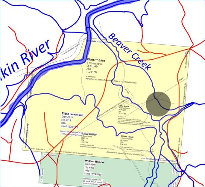
The 400-acre Isaacs grant was divided
beginning in 1784. (Larger version) The map above shows the 400-acre Elijah
Isaacs grant with the approximate cabin location at the shaded circle. The thin black lines with metes and bounds
show the approximate division with the 230 acres in the northwest, the 50
acres somewhere in the middle, and the 120 acres in the southeast. Yes, it looks messy! But unfortunately, the associated deeds
don’t provide enough details to fully draw the boundaries of these
deeds. It’s not clear which of these
parcels was the site of the cabin, but that’s not necessarily relevant if the
Triplett family had consolidated them.
Perhaps the more important point is that these deeds provide the names
of the landowners during the late 1700s. Records and Family Stories Come
Together Looking again at William Allison’s
deposition, he said that Mrs. Triplett’s 400 acres is where George Boone’s
cabin was. I’m starting to believe
that Mrs. Triplett was Eleanor who had acquired all (or most) of the old
400-acre grant. William Allison would
certainly know who had lived there because he had lived on the south side of
this land for the past 40 years. Also,
it’s hard to imagine there being another “Mrs. Triplett” who lived on a
400-acre farm on Beaver Creek. When we consider William Allison’s
testimony, the old deeds, and the family story about the long-remembered
Boone cabin, they all come together to suggest that the cabin might have
belonged to George Boone, Daniel’s younger brother. There was certainly a cabin there as shown
in the 1950s photo. At that time it
was a pile of rocks, and they were removed in the 1960s. Landowners in the years since verified the
location of those rocks. Another piece of circumstantial
evidence is the fact that Thomas Linville acquired the southeast portion of
the old grant. George Boone was
married to Ann Linville who was born about 1744. With the same last name, she must be related
to Thomas Linville who was buying and selling this land in the 1780s. Perhaps they were siblings? Even though George and Ann had moved to
Kentucky by the 1780s, it’s interesting that one of Ann’s relatives had
bought part of the land where they had lived. I had another thought. This isn’t based on facts, but I’m just
thinking out loud. Daniel Boone was in
Wilkes County from 1767 until 1773, or about six years. There are at least four places between
Wilkesboro and Ferguson that are suggested as former homesites of Daniel
Boone. Would he have moved his family
to a new cabin every year or two while he was here? Maybe, but it seems as if that wouldn’t be
necessary or practical for a man who was more interested in spending his time
exploring and making frequent trips into the wilderness of Kentucky. Perhaps one or two of these suggested
homeplaces weren’t actually his, but instead belonged to other members of his
family. Perhaps the stories were
passed down through generations that a particular site was “the old Boone
place”, and over time that story innocently evolved into being “the old Daniel
Boone place”. Records show that Daniel Boone lived in
at least two locations in Wilkes County:
one at the mouth of Lewis Fork, and the other at the mouth of Elk
Creek. Both were on the north side of
the Yadkin River. He very well might
have lived at other places along the river, but I haven’t seen documentation
for those yet. It’s exciting that we have
evidence of his brother living at this site on Beaver Creek, and Daniel
surely would have stopped by to visit him here, telling stories about his
adventures across the Blue Ridge Mountains.
I’m sure there are more records hidden away that will give a more
complete picture about Daniel Boone’s time in Wilkes County, so we’ll need to
continue searching. Knowing where his
family lived – including his brother George Boone – will be helpful in
learning more about Daniel, himself.
Comment below or send an
email - jason@webjmd.com |
|
|