Blog
Article List Home My Research Services Contact Me
|
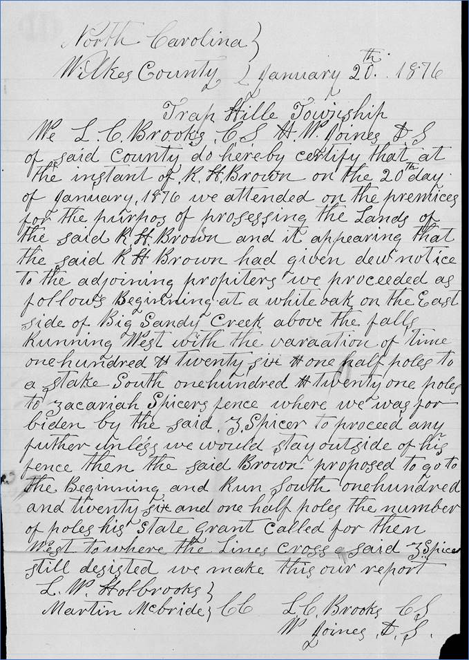
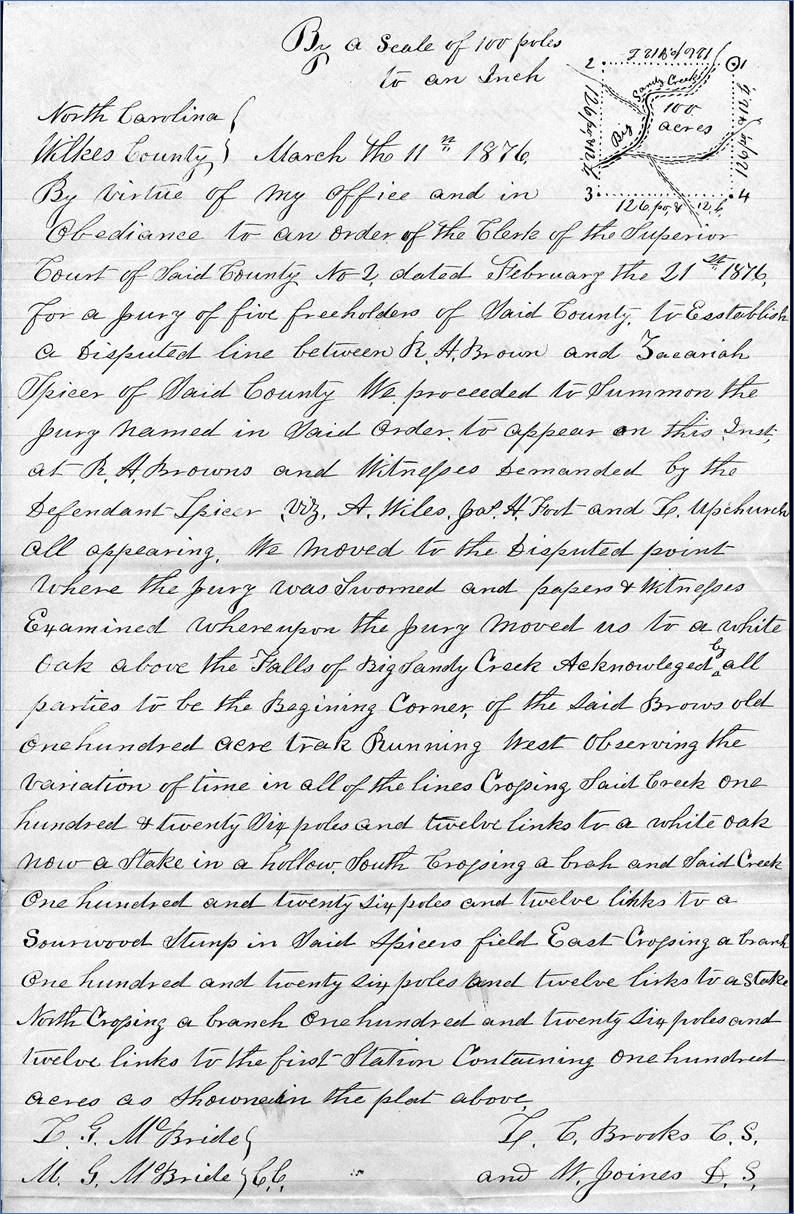
Wilkes June 8, 2023 The Dispute Below The Falls
– Brown vs Spicer On January 20, 1876, Richard Brown stood
out in the cold as he observed the county surveyor Larkin C. Brooks and
deputy surveyor Wesley Joines surveying his 100-acre tract of land at the Lower
Falls on the south side of Stone Mountain.
He had owned this land for twenty years, and he wanted confirmation
about where the four corners were located.
Everything started out fine while marking the north side of the
property, but when the surveyors moved south while marking the western
boundary, they were stopped by Zachariah Spicer who forbid them from crossing
his fence. The survey would not be
completed today.
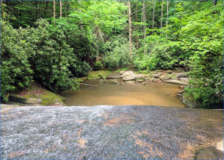
The
Lower Falls at Stone Mountain. As was the standard practice, when
surveyors were met with a disapproving land owner, they didn’t engage in the dispute. They packed up their equipment and reported
the incident to the court which would determine how to proceed with the
property boundary dispute.
The
surveyor’s report from Brooks and Joines describes their surveying attempt in
January 1876. Richard Brown’s Property Richard H. Brown owned over 500 acres
at Stone Mountain in the mid-1800s including most of the trail that leads
from the Hutchinson Homestead out to the Upper Falls. His property included the entirety of the trails
that lead to the Middle and Lower Falls, extending south to a point just
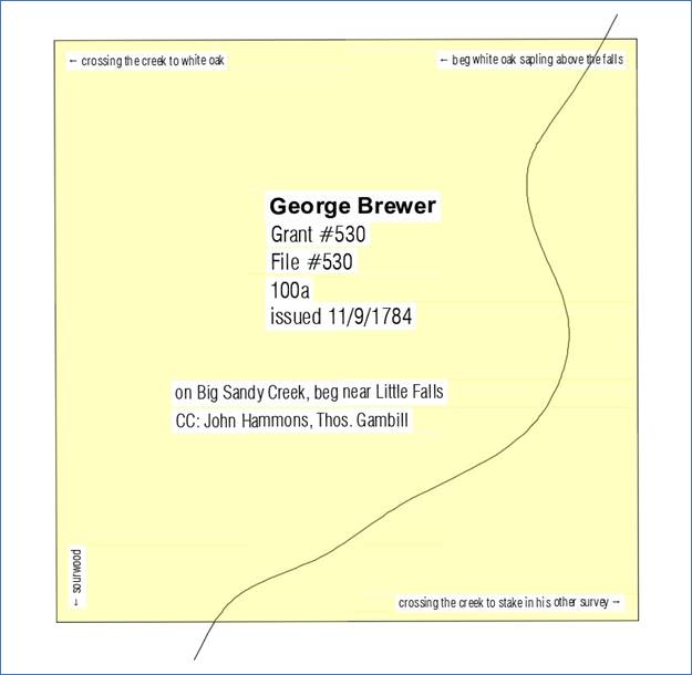
beyond the park’s boundary at the end of Traphill-Brown Rd. One particular tract of land that he
owned was for 100 acres which included the Lower Falls. It was originally granted to George Brewer
in 1784.
The
original 1784 land grant for the 100 acres describes it as being on Big Sandy
Creek near the “Little Falls”. George Brewer lost this land in 1796
when it was sold by the sheriff to Benjamin Adams. The deed (DB, p97) says that the court
ordered the sale of Brewer’s land to “cause to be made the sum of twelve
pounds, eighteen shillings, 11 pence which was recovered against him the said
George Brewer by Stephen Holiway”.
Apparently Brewer owed Holloway a sum of money, and Holloway took him
to court to get it. (As a side note, Stephen Holloway was Brewer’s
neighbor. Stephen Holloway – the progenitor
of all the Holloways of Wilkes County – was the first to live at the site of
the Hutchinson Homestead, even though he never officially purchased that
land. It was first bought from the
state in 1817 by John Brown who was the father of Richard H. Brown. Later, in 1858, John Hutchinson bought that
land where several generations of his family would live.) Returning to the 100-acre tract that is
in dispute, it was owned by William Williams until 1814 when he sold it to
William Edwards. William Edwards sold
it to Richard H. Brown in 1856. And in
1876, we’re standing out in the cold as the surveyors are packing up their
transits, compasses, and chains after being unable to complete the
survey. So why was Richard having his
property surveyed 20 years after he purchased it? Zachariah Spicer I checked the deed book indexes, but
there aren’t any deeds listed to or from Zachariah Spicer in this time
period. My first thought was that
these deeds must be missing. We know
Zachariah Spicer existed because he is listed in the censuses. He was born in 1852 and married Micah
Paulina Hall on August 26, 1875. Only
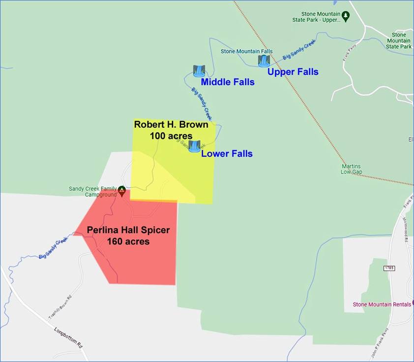
eleven months before their marriage, Paulina had inherited part of her father’s
estate which consisted of 160 acres on the southern border of Richard Brown’s
land. Therefore, Zachariah Spicer
never purchased the land. Instead, he
acquired it with his marriage to Paulina.
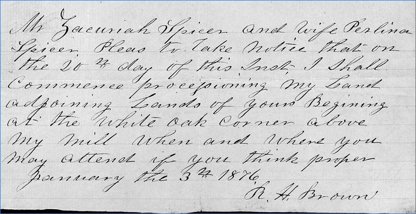
Four months after his marriage, 23-year-old
Zachariah Spicer was causing trouble for his neighbor. I imagine that Zachariah was clearing land
and installing a fence on what he felt like was the northern edge of his
land. Perhaps Richard Brown, a generation
older, explained to him that he had crossed the property line and that he
should construct his fence a short distance to the south. Zachariah refused, so Richard Brown called
the county surveyor.
Paulina
Hall inherited 160 acres (shown in red) from her father Owen Hall in
1874. She married Zachariah Spicer in
1875. The Second Survey Attempt A month after their first attempt, the
surveyors returned with a court order to complete their work. This time, a larger crowd was present. In addition to the two surveyors, the court
appointed a jury to oversee the process.
This included Joseph S. Holbrook, Lewis W. Holbrook, Henderson McGrady,
J. Alfred Johnson, and Samuel Caudill.
Additionally, Zachariah demanded that he bring witnesses A. Wiles, James
H. Foote, and L. Upchurch. With enough men to field a football
team, the surveying began once again.
Everyone agreed with the starting corner which was a white oak above
the falls of Big Sandy Creek. When they ran south along the west line, they
crossed Zachariah’s fence and ended at a sourwood stump in his field. Just as Richard Brown had said, Zachariah’s
fence was too far north.
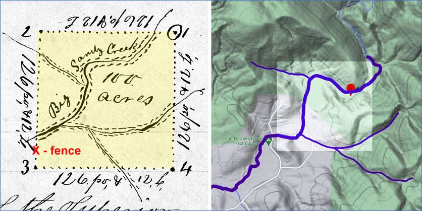
Surveyors’
report from their second attempt on February 21, 1876. Notice the small sketch in the upper
right corner of the report (and reproduced below). It shows the 100-acre tract with Big Sandy
Creek running through it. The northeast
corner is the beginning white oak. The
surveyors moved west to the the second corner, then south to the third corner
where they ran into Zachariah Spicer’s fence.
Comparison
of the survey sketch and the topo map. When comparing the survey sketch with a
topo map from today, the tributaries of Big Sandy Creek line up surprisingly
well! The third corner, which came to
a sourwood stump in Zachariah Spicer’s field, is still a field within Sandy
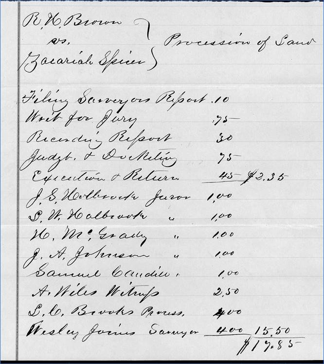
Creek Family Campground. The cost of the survey, with all of the
reports and witnesses, was $17.85.
While the court papers don’t state who paid these fees, it was likely
Zachariah Spicer since he was in the wrong.
The
cost of the survey was $17.85. Richard Brown’s Mill One other surprise that is revealed in
these records is the fact that Richard Brown owned a mill on this
property. When Brown notified
Zachariah Spicer about the upcoming survey, he described the meeting point as
“the white oak corner above my mill”.
In the original 1784 grant, it was “the white oak above the little
falls”. So perhaps Richard’s mill was
located very close to the cascade that we know as the Lower Falls.
Zachariah
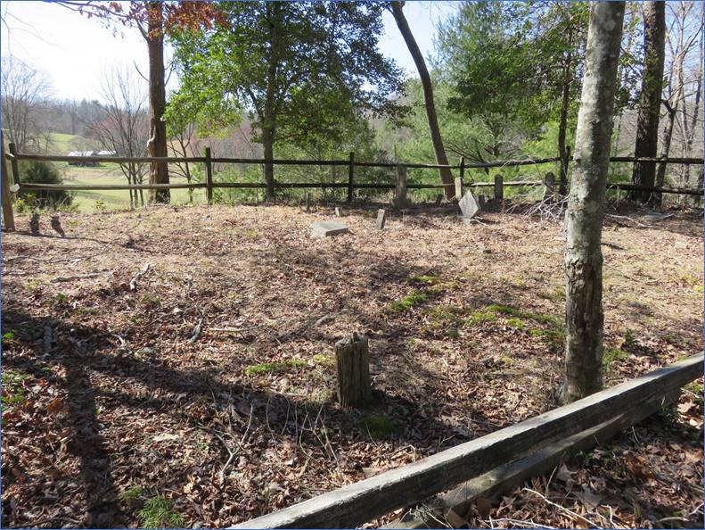
Spicer was notified of the upcoming survey in January 1876. One other landmark within this 100-acre
tract is the Brown Family Cemetery. It’s
at the south end of the state park, overlooking a field not far from his
disputed corner.
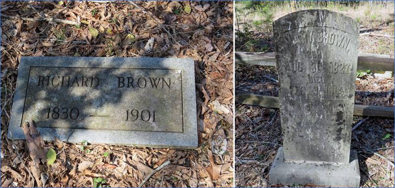
The
Brown Family Cemetery is located on Richard Brown’s 100-acre tract. Richard H. Brown (1830-1901) is buried
here with his wife Mary Joines Brown (1827-1914), along with several of their
children and grandchildren.
The
Brown Family Cemetery, looking south from the edge of the state park.
Headstones
for Richard Brown (1830-1901) and his wife Mary Joines Brown (1827-1914).
Comment below or send an
email - jason@webjmd.com |