Blog
Article List Home My Research Services Contact Me
|
Wilkes April 16, 2025 Wilkes Land Grants – April 2025
Update I updated my Wilkes County Land Grants page
with an updated table and map. This is
a week-long process that involves multiple steps of exporting files from one software
program and importing it into another.
After I work out the bugs from all of that, the last step is to upload
everything to the server. This is 2.3
GB worth of data, and the upload, itself, takes nearly 24 hours!
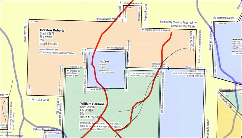
Sample
of land grants on the headwaters of Warrior Creek. This update is special because it
includes a new feature. For the first
time, both the table and the map include select land grants from surrounding
counties. Over the years, county
boundaries changed many times. For
instance, the northern part of Wilkes became Ashe in 1799. In order for me to map a 1798 Wilkes land
grant along the Blue Ridge Parkway, I need to draw and map a later Ashe
County land grant that adjoins it. Further
complicating matters is the fact that part of Ashe County later became
Alleghany County in 1859. I need to
search through three counties to confidently place one early Wilkes grant. The same situation occurred in the
southwestern part of Wilkes with the county line changing between Burke and
Wilkes, and then the formation of Caldwell in 1841. I have drawn and located 389 non-Wilkes
land grants, and those are now listed in the table. And for that reason, the table now has a
column for “County” which can be filtered just like the other columns.
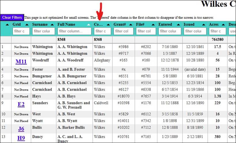
A
new column is provided for the county of the land grant as noted by the red
arrow. I have now drawn 5,184 of the 7,979 Wilkes
County grants, or 65% of them. I have actually placed on the map 4,144
of the 7,979 Wilkes grants, or 52% of them.
Most of the remaining 48% are not within the present-day county boundaries. There are just over 1,000 land grants that
have been drawn, and which are patiently waiting just outside the edge of my
map until I identify where they should be positioned. The present-day boundaries of Wilkes
County are nearly filled with the red, blue, yellow, and green splashes of
color that represent these land grant puzzle pieces.
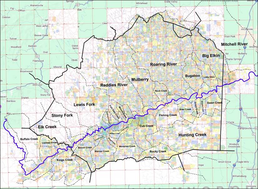
Land
grant map after the April 2025 update. I haven’t done much work yet on Elk
Creek or Stony Fork. I have started
Lewis Fork, Reddies River, Fishing Creek, and Hunting Creek, but I still have
a lot of work to do with those.
Outside of present-day Wilkes County, I have made a lot of progress on
Laytown Creek and Kings Creek which are in Caldwell County. You can get access to all of my Wilkes Land
Grant information on one page. The
two most useful tools are the Searchable Table (#1) and the Map (#2). There is also an explanation of how the
table and map are setup on the Explanation page (#3). Other links show various reports and a map
of the watersheds for Wilkes County. If you’ve visited the site before, you
might need to refresh the page for it to display the new files. (I had to do that.) On the map page, be sure to take advantage
of the tools in the upper right corner.
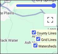
Helpful
tools are in the upper right corner of the map. The blue slider adjusts the transparency
of my land grants layer on top of the Google Map. The three toggles turn on/off the County
Lines, Grid Lines, and Watershed lines.
The upper LEFT part of the map allows you to switch between “Map” view
and “Satellite” view. Happy hunting! Wilkes Land Grants: http://webjmd.com/wilkeslandgrants
Comments? Want to join my mailing list? Email jason@webjmd.com |