Blog
Article List Home My Research Services Contact Me
|
Wilkes October 9, 2025 The 50-Acre Town of
Wilkesboro: Lot #3 I’m working on a history of the
original 36 lots that were created by William Lenoir to form the town of Wilkesboro
in 1800. Occasionally, I’ll post chapters
online as I continue working on this project.
Eventually, I’ll turn this into a book with maps, photos, and court
cases that tell the individual stories of each lot. Look for that in 2026. If anyone has old photos that show the
people and places in the early days of the town, please let me know! jason@webjmd.com With this first article, we’ll look at Wilkesboro
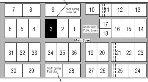
town lot #3 which is where the Wilkesboro Police Station is today at the northeast
corner of Main Street and West Street. Lot #3 Original Lot Size: 1
acre Primary Addresses Today: 108,
110 W. Main St 100,
102, 104 N. West St Notable Properties: Wilkesboro
Police Department
Earliest Owners
Before William Lenoir laid out the town
streets in 1800, he owned a house on what became lot #3. It was located on the eastern edge of a
150-acre tract from which Lenoir sold 22 acres for the creation of the town. In the 1790s, this house was occupied by
Thomas Robins who maintained the property and tended nearby fields for
Lenoir.1 On May 23, 1800, a deed for town lot #3
was issued to John McGuire for $81. Two
years later, John McGuire of Iredell County sold the lot to Patton &
Erwin for $150. On January 1, 1812,
they sold the lot to James Shepherd and Richard Gwyn. In 1819, they sold lots #2 and #3 to a
third pair of business partners, William P. Waugh and John Finley. In 1835, William P. Waugh paid property
taxes on the lot which was valued at $500.2 When John Finley sold his share of several
lots to his partner William P. Waugh in 1845, lot #3 was described as adjoining
the cross street leading to the dwelling house of Dr. Larkin G. Jones.3 Dr. Jones lived near the top of the hill
where the Wilkes County office building is now located. In 1851, William P. Waugh was taxed on
two town lots which, together, were valued at $4,000. He was taxed on an additional 764.5 acres
valued at $5,500 with a note that says “brick house place C & M Creek”. This refers to his brick home near Moravian
Falls.4 It is notable that his
town lots were valued at $2,000 per acre, while his farmland was valued at
just over $7 per acre. As described in the chapter about lot
#2, a new lot was created from portions of lots #2 and #3, and it was sold to
R. F. Hackett in 1854.5 That
newly-created lot became the home of J. T. Ferguson. The western part of lot #3 must have been
sold by William P. Waugh’s executor John Waugh sometime after 1852, but a
deed has not been found. By 1873, the western part of lot #3 was
owned by James and M. A. Gwyn. They sold
it to Samuel J. Ginnings on October 4, 1873.
On February 13, 1891, Ginnings sold this 2/3-acre lot to Martha
McBride and D. E. Ginnings for $2,000.
Dianah E. Ginnings was Samuel’s wife, and two thirds of this lot was
in her name. Martha McBride was his
wife’s mother, and one third of the lot was in her name.6 Samuel died in 1914, and his wife Dianah
died on May 1, 1927. Her will
specified that her house and lot on Main Street was to be given to Floyd G.
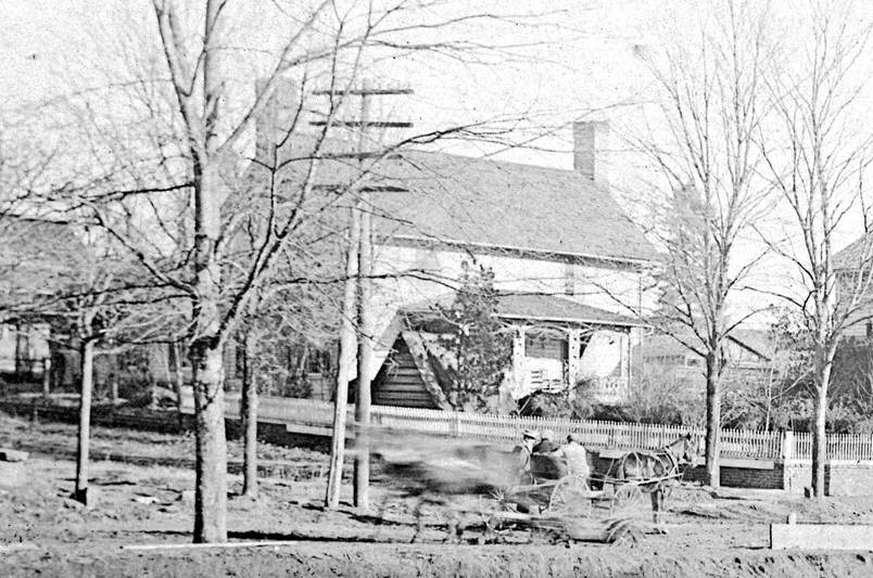
and Ila Spainhour Holman.7 The photo below was taken in 1916, and
it shows the house on the western side of lot #3 at the northeast corner of
Main Street and West Street. At that
time, this would have been the house of Diannah McBride Ginnings, widow of
Samuel J. Jinnings. It is a large
two-story house with chimneys at both ends and a front porch. It is shown on the 1920 and 1926 Sanborn
maps, and it is visible in aerial photos from 1958 and 1963. The next available aerial photo is from
1983, and the house is no longer there at that time.8 Today this is the site of the Wilkesboro
Police Department.
This photo was taken January 3, 1916, during
construction of the new federal courthouse at the corner of Main Street and
West Street. The white picket fence runs
up the hill along West Street. The
stationary horse and buggy are facing east on Main Street. Another horse is blurred as it travels west
pulling a construction wagon. Courtesy
of Wilkes Heritage Museum.
1. 1800 Survey Map made by William Lenoir in 1800 to create the
town of Wilkesboro. Lenoir Family
Papers, series 4.4.3. 2. Tax Records (Wilkes County, North Carolina), 1778-1908, image
group number 7834322, image 118 of 1,198 on familysearch.org. 3. Wilkes DB T, p24. 4. Tax Lists (Wilkes County, North Carolina), 1778-1859, image
group number 7834323, image 641 of 1,017 on familysearch.org. 5. Wilkes DB S, p402. 6. Wilkes DB 142, p2. This
1891 deed references the 1873 purchase from James and M. A. Gwyn. 7. Wilkes WB 9, p2. 8. historicaerials.com
Comments? Want to join my mailing list? Email jason@webjmd.com |