Blog
Article List Home My Research Services Contact Me
|
Wilkes December 19, 2024 Wilkes County’s First
Landowners Back in 2022, I wrote about the
Granville Grants that were issued in present-day Wilkes County. These grants were tracts of land that were
sold by Lord Granville, a British citizen, while North Carolina was still a
British colony. I identified six
tracts of land along the Yadkin River, and possibly two more for which there
are no documents today. The six
documented tracts were purchased in 1752 and 1754 by three different buyers. Now, let’s skip ahead 25 years to
September 1777. The tax collectors of
Surry County are making their tax lists and checking them twice. In just two months, the county will be divided
for the purpose of forming Wilkes County from the western portion. Three tax collectors are responsible for
collecting the taxes for the area that will become Wilkes. (A fourth district likely included the
watershed of Hunting Creek, but I haven’t identified which district yet. Much of that district probably remained
part of Surry County.)
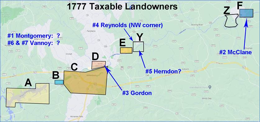
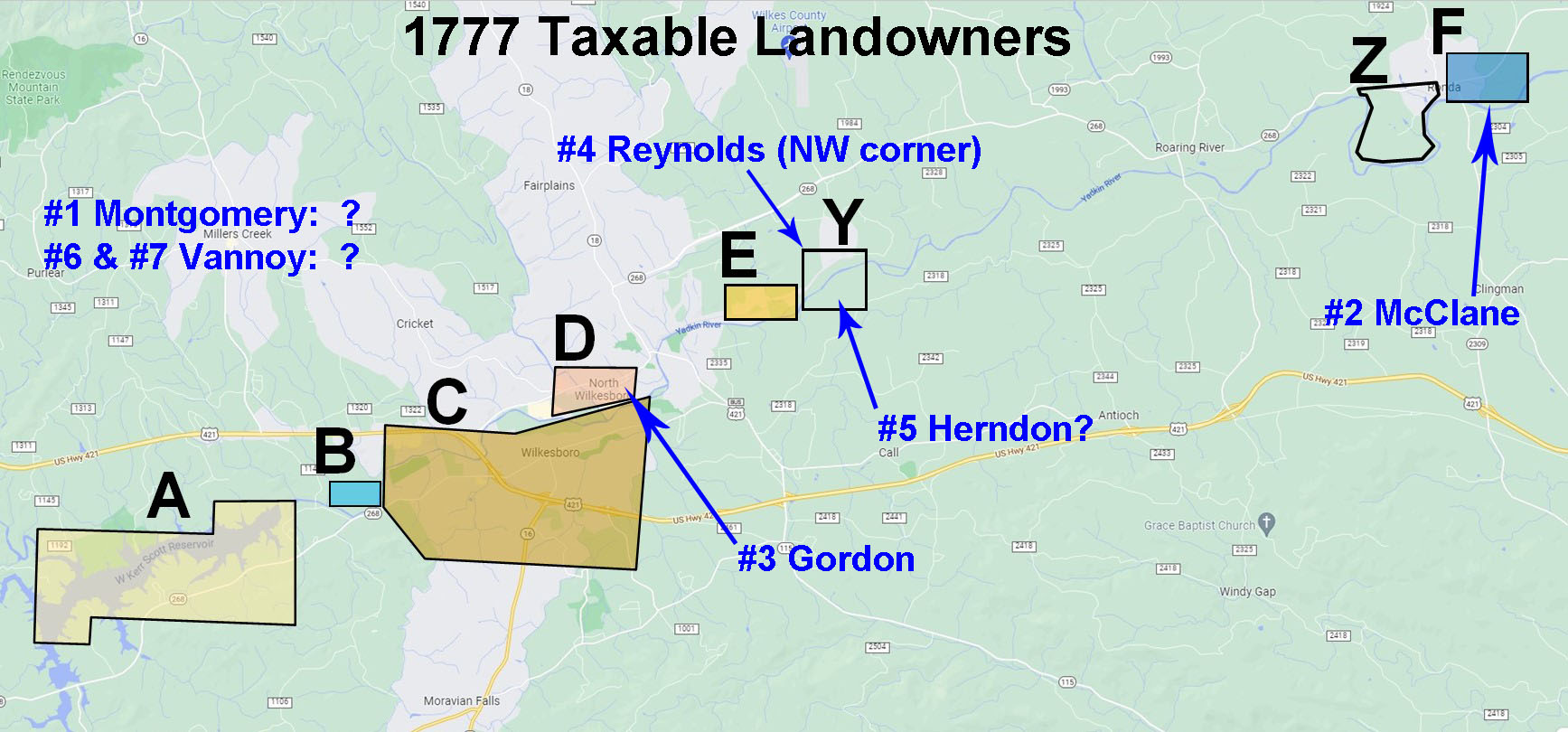
1777 Surry County tax
districts. The 1777 county tax was based on the
value of the family’s personal property.
The categories that were counted were:
land, improvements, negros, horses, cattle, money, interest money, and
stock money. Within the three
districts that would soon become part of Wilkes County, only seven people
were listed as owning land that was to be taxed: Hardgrave’s District #1 Hugh Montomery – 1 piece Cleveland’s District #2 William McClane – 314
acres Herndon’s District #3 Charles Gordon – 354
acres #4 Francis Reynolds – 40
acres #5 Joseph Herndon – 380
acres #6 Nathaniel Vannoy – 107.5
acres #7 Daniel Vannoy – 107.5
acres I added numbers before each name for
easy reference. Why were there only seven landowners in
soon-to-be Wilkes County in 1777?
There were 282 families listed in these district tax lists, and surely
more than seven of them owned land!
Apparently not. Most of them
were squatters, living on the land without formal deeds. North Carolina opened its land office
in 1778 as ties were being severed with Great Britain. Until the Declaration of Independence in
1776, North Carolina was still considered a British colony, and any purchase
of unclaimed land had to be purchased from the British owner of land in this
part of the state, and that man was John Carteret, 2nd Earl
Granville. His office sold tracts of
land in the northern part of the colony until his death in 1763. In the years that followed, his land office
remained closed, and land was no longer sold to newly arriving settlers. This meant that no one could purchase
unclaimed land from 1764 until 1778. Returning to our 1777 list of seven
landowners, any land that they owned by deed must have been originally
purchased from Lord Granville before 1764 because there were no new British
deeds after that date. Let’s take a
look at these seven landowners and try to determine how they obtained their
land. Ideally, each of their tracts
should be traceable back to a Granville Grant from 1752 or 1754. #1 Hugh Montgomery Hugh Montgomery is the only landowner
in Hardgrave’s District. His entry in
the tax list shows that he had “1 piece” of land, 3 improvements, 10 negros,
70 horses, and 135 cattle. He was one
of the wealthiest people in soon-to-be Wilkes County, but curiously, the
“money” column is blank. Since he
actually lived in Rowan County, maybe his cash and coins were taxed
there.
1777 Surry County tax entry
for Hugh Montgomery. Of the seven landowners, Montgomery is
the only one where the acreage is not listed.
I assumed that was because he had purchased the two Moravian tracts
totaling 8,773 acres. Perhaps such a
large quantity of land was nebulous, and it was thought of as a giant swath
of land. But there’s a problem with
that theory. Montgomery’s purchase of the two Moravian
tracts are recorded in Wilkes County deed book A1 on page 174 and 178. The transaction is dated July 23, 1778, and
it was proven at the March 1779 term of court. That’s ten months AFTER this tax list. Montgomery didn’t own the Moravian land when
this tax list was made. I searched Wilkes, Surry, and Rowan
deed books for any other land that might account for Hugh Montgomery’s “1
piece” of land, and I found one possibility. Surry County deed book A, page 24, has a
deed from Benjamin Angel to Montgomery dated September 10, 1772. The sale consisted of several horses and
two parcels of land. The first was “one
improvement and parcel of land lying on Elk Creek”, and the other was “one
improvement and parcel of land lying on Thomas Linville’s Mill Creek.” The sale would be void if Benjamin Angel
paid Montgomery £27/12s/10p before the following February 10. I don’t know if debt was paid or not. If it wasn’t, then Montgomery owned these
two vague parcels of land at the western edge of present-day Wilkes County. I checked Surry and Rowan deed books
trying to find how Benjamin Angel acquired this land, but I didn’t find
anything. My guess is that he didn’t
purchase these two tracts by deed. He
probably squatted on the land, cultivated it, and claimed it by axe
entry. The only reason his “ownership”
is documented is because he effectively mortgaged it to Hugh Montgomery. We still don’t know if this is the land on
which Montgomery was taxed in 1777, but since the entry vaguely says “1 piece”,
I tend to think that the land was not from a Granville Grant and that there
was no official deed for it. I had thought that Hugh Montgomery’s
land would be the easiest to identify, but that’s not the case. We know that it was in Hardgrave’s District,
and that means it was somewhere west of Wilkesboro. #2 William McClane William McClane is the sole landowner
in Cleveland’s District. He owned 314
acres, 2 improvements, 1 negro, 5 horses, 14 cattle, £12/17s money, and £984
interest money. This must be the Hughes Bottom tract on
the east side of Ronda along NC Hwy 268.
I wrote
about this 1752 Granville Grant to Edward Hughes back in 2022. It is Anson County land grant file
#1050. Edward Hughes sold it to John
Howard in 1763 (Rowan DB 5, p418).
Howard sold it to John Mitchell in 1767 (Rowan DB 6, p384). Then there is a gap in the records, and the
next time this property appears is in 1792 when William Powe sold it to
Richard Gwyn (Wilkes DB B1, p307). I haven’t found a deed where John
Mitchell sold it after 1767, and I haven’t found a deed where William Powe
bought it before 1792. During this 25
year period, the Hughes Bottom tract was in Rowan, Surry, and Wilkes, and
that makes the search more difficult, but I’ve looked in the deed indexes for
all three counties. It’s not unusual
to be missing a deed from this time period.
I’m confident that this is the property owned by William McClane in
the 1777 tax list because the acreage matches (there aren’t many 314-acre
tracts) and it is within the area covered by Cleveland’s District. This is an example where the tax list fills
in the gap caused by missing deeds. #3 Charles Gordon Charles Gordon was listed in Herndon’s
District with 354 acres, 1 improvement, 18 negros, 7 horses, 30 cattle, and £12/5s
money.
1777 Surry County tax entry
for Charles Gordon. This was the Mulberry Fields
tract. Charles Gordon bought this land
from John Payne on November 27, 1775 for £325 (Surry DB A, p209). It describes the property as being “on the
north side of the Yadkin River above the mouth of Elk alias Reddys River”. That’s right, Reddies River was previously
known as Elk River! This Surry County deed says that the
land was originally granted to Morgan Bryan “by the late John Earl Granville”
in 1752. Morgan Bryan then sold it to
Joseph Bryan in 1756. Joseph Bryan(t)
sold it to Marmaduke Kimborough in 1765 (Rowan DB 6, p232). Kimborough sold it to John Payne in 1767 (Rowan
DB 6, p502). All owners are accounted for, and Charles
Gordon was the fifth person to own this tract of land. All of these transactions occurred before
Wilkes County was created. The
Mulberry Fields tract would remain in the Gordon family for many years, and today
most of downtown North Wilkesboro is on this tract of land that goes all the
way back to 1752. #4 Francis Reynolds Francis Reynolds is listed with 40
acres, 1 improvement, 3 negros, 19 horses, 22 cattle, £151/1s money, and £64/14s
interest money.
1777 Surry County tax entry
for Francis Reynolds. Francis Reynolds bought 40 acres from
John Howard in May 1769 (Rowan DB 7, p90).
This land was on the north side of the Yadkin River, just below the
mouth of Mulberry Creek. It was the
northwest corner of the White’s Bottom tract.
John Howard purchased the entire tract from William Todd Livingston in
1765 (Rowan DB 6, p265). The deed does
not specify the acreage of the tract, but as drawn by the metes and bounds,
it is 505 acres. There is also a Wilkes County deed for this
same property (this time 39.5 acres) where Francis Reynolds purchased it from
Joseph Herndon in 1779 (Wilkes DB A1, p99).
It’s not clear why Francis Reynolds purchased it twice. It’s possible that he bought it in 1769,
sold it, and then bought it back in 1779.
Or, there could have been a concern that the earlier Rowan County deed
wasn’t sufficient. We’ll talk more
about this as we move to the next landowner. #5 Joseph Herndon Joseph Herndon was listed with 380
acres, 2 improvements, 9 negros, 10 horses, 18 cattle, and £4 money. 1777 Surry County tax entry
for Joseph Herndon. There are no Surry County deeds to
Joseph Herndon between 1771 and 1778.
I haven’t found any Rowan County deeds to him, either. None of the Granville Grants are for 380
acres. This looks like a dead end, but there
might be a clue in the deeds to Francis Reynolds who owned 40 acres of the
White’s Bottom tract below the mouth of Mulberry Creek. When Reynolds purchased his land for the
second time, he bought it from Joseph Herndon. That means Joseph Herndon owned it before
1779 even though no deed has been found for his purchase. It’s also possible that this missing deed
to Joseph Herndon was for the entire White’s Bottom tract. The acreage isn’t given in the 1765 deed to
John Howard, but the metes and bounds calculate to 505 acres. We know that Francis Reynolds owned 40 acres
of it, and that leaves 465 acres. If
Joseph Herndon also sold an 85-acre corner of the tract to someone else, that
would leave him with 380 acres. That’s a lot of “ifs” and “maybes”! But we know there are missing deeds between
the time when John Howard bought it in 1765 and the next deed in 1799 when the
heirs of John Payne sold it to the Rousseau family (Wilkes DB D, p528). It’s very possible that Joseph Herndon
owned 380 acres of this land in 1777. I should mention one other deed in case
it becomes relevant with future research.
Joseph Herndon purchased 367 acres from John Payne on September 12,
1778 (Wilkes DB A1, p10). This tract
was at the mouth of Mulberry Creek, originally granted to Morgan Bryant in
1752 as 313 acres. This deed is twelve
months too late to be the land listed for Joseph Herndon in the 1777 tax list,
but the land adjoins the western edge of the White’s Bottom tract. Perhaps, in 1778, Joseph Herndon purchased
the original 313-acre grant along with a portion of the adjoining White’s
Bottom tract. As for the White’s Bottom tract,
itself, it must have been a Granville Grant, but the documents are not on
file. Presumably, it was issued sometime
before John Carteret’s death in 1763. If John Payne owned this in 1777,
before selling it in 1778, then why wasn’t he taxed for it? He lived in Virginia, but wouldn’t he still
be taxed on his property? Then again,
the Moravians aren’t listed in this district either, and they owned 8,773
acres. But they are likely listed in one
of the other Surry districts in the eastern part of the county since that’s
where they lived. In fact, John.
Michael Graff is listed with £24,000 taxable property in Capt. Smith’s
District. Some of that could be the
Wilkes land. #6 Nathaniel Vannoy and #7 Daniel
Vannoy Nathaniel and Daniel Vannoy each owned
107.5 acres in the 1777 Surry tax list.
Nathaniel had 7 horses, 15 cattle, and £1/13s money. Daniel had 4 horses, 10 cattle, and 6
shillings of money.
1777 Surry County tax entries
for Nathaniel Vannoy and Daniel Vannoy. Nathaniel Vannoy (born 1749) and Daniel
Vannoy (born 1752) were brothers, and the sons of John Vannoy. The family moved from New Jersey to
present-day Davidson County, NC, in the 1750s, and then to Wilkes County in
the 1770s. Roberta
Estes has written a very thorough article on this Vannoy family. It’s easy to imagine that Nathaniel and
Daniel are sharing a 215-acre tract, but I haven’t been able to identify
it. Their father John Vannoy is
thought to have died in the 1770s, and maybe they split the land from his
estate. I looked in Surry and Rowan
deed indexes, but I didn’t find where any Vannoy purchased 215 acres in this
part of the county. They are listed in
Herndon’s district which includes the watersheds of Rock Creek, Mulberry
Creek, and Reddies River. I imagine
their land was close to the Yadkin River only because all of the other land
owned in 1777 has been along the river. There aren’t any other Granville Grants
that could account for these two 107.5-acre tracts. With such a specific number, it seems like
there should be a deed for when they bought it, but if there was, it has
likely been lost. The location of the
Vannoy land remains a mystery for now.
Report Card I was able to locate the property of
three of the seven landowners in 1777.
Those were McClane, Gordon, and Reynolds. The other four (or, three if you group the
Vannoys together) are still a mystery:
Montgomery, Herndon, and Vannoy.
I’m 60% in favor of saying that Herndon’s
380 acres was part of the White’s Bottom tract (“Y” on the map). After originally thinking that Montgomery’s
property was the Moravian land, I no longer believe that. It was probably never officially deeded
land since a specific acreage wasn’t given.
It could have been Benjamin Angel’s 1772 improvement, or perhaps it
was another, more recent acquisition.
The Vannoy land was probably between Rock Creek and Reddies River, but
its exact location is a mystery.
Land owned by the seven
landowners in the 1777 Surry tax list. I’ve published two books on the Wilkes County
tax lists of the late 1700s, and you can read more about those on my
website. The newest book includes tax
district maps for every year between 1777 and 1799.
Comment below or send an
email - jason@webjmd.com |

