North Carolina and Virginia Genealogy
Jason Duncan, Statesville, NC
Information About Each Grant
All of the information for each grant can be found in the Searchable Table. Below is an example from the grants table.
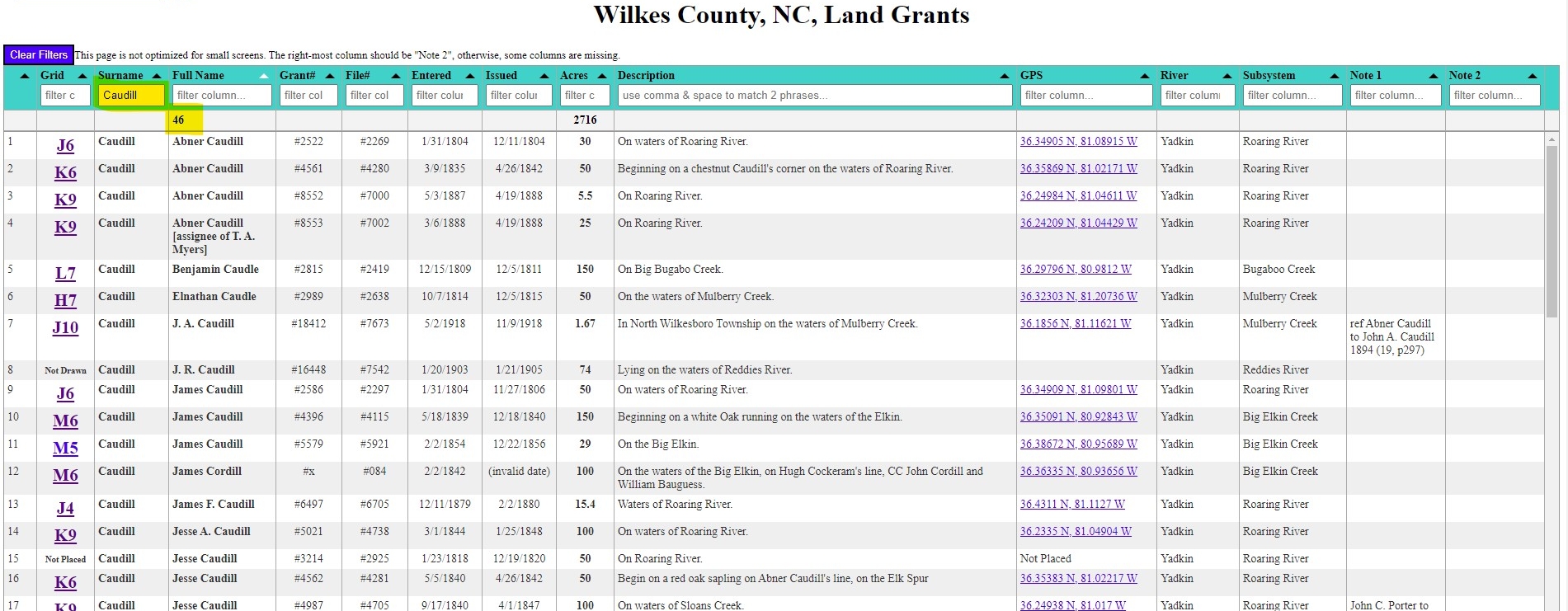
Grid
This is the location of the grant on my map. The map is divided into grid squares that are 15,000 ft x 15,000 ft, or about 8 square miles. The location of a grant is determined by the starting point for the metes and bounds in the survey. Click the grid (i.e. K6, C11, etc) to view that grant on the map in a separate tab. The map will open at the GPS coordinates of that grant. Switch between the two tabs to view the data and the map. Remember to use the blue slider in the upper right corner of each map to adjust the transparency of the grants layer!
"Not Drawn" in the grid column means that I haven't drawn this grant yet. "Not Placed" means that I have drawn it, but I haven't determined where it is located.
Surname
Generally, this is the last name of the person receiving the grant. When the grant was made to more than one person, I used the last name that was provided first. If the grant was made to a corporation or business, I picked the primary word in the title. I intentionally standardized on the spelling of these last names to make them easier to find in an alphabetized list.
Full Name
This is the full name of the person or group receiving the grant. Many times, these names are spelled multiple ways within the records, so see the originals if you want to know exactly how their names were spelled. A note saying "assignee of..." means that the person that the grant was issued to was not the first person who entered the tract of land. Perhaps one person considered buying the land, but later changed his mind. He could transfer the opportunity to buy it to someone else.
County
In addition to the nearly 8,000 Wilkes County grants, I have drawn select grants from surrounding counties. The county boundaries changed in the early years, and these other county grants are helpful in placing early Wilkes grants. In 2025, there are 389 grants on the map from other counties.
Grant # and File #
The grant number is the number assigned at the time the grant was issued. Perhaps due to poor record keeping, sometimes the same grant number was used multiple times. The file number is the number assigned to the record by the NC State Archives. Every grant has a unique file number. I've also included grants that were apparently never officially issued. For those, the grant number and the issue date will be blank. Perhaps the person changed his mind and never bought the land. Or, maybe the issue papers were lost.
Entry Date and Issue Date
The entry date is when land was claimed or when someone made a request to purchased vacant land. This was the first step of the process. It was later surveyed to define the boundaries, and the final step was for it to be officially issued to the grantee. This final date is the issue date.
Acres
The amount of land that was officially issued to the grantee. The maximum amount an individual could claim in one grant was 640 acres.
Description
A brief description of the grant from the text of the original paperwork. For most of these, this is the description recorded by the State Archives and written on the outside of the shuck file. For some, I added more information from the survey.
River and Subsystem
I looked at every grant file to determine the main watershed where the land was located. As an example, File #2269 is located within the Yadkin main watershed, and on the Roaring River subsystem. Some locations were easy to determine because the grant said "on the waters of [creek name]". Sometimes that wasn't provided, and I used other clues to research the location. If I wasn't able to determine the location, it is listed as "Unknown".
Note1 and Note2
These two fields are for any notes that I made about the property. Often, these notes are deed references for when the property was later sold.