Elkin History
-
Shortcuts:
- Elkin History Articles
- David Allen's Iron Works
- Old Elkin Photos
- Maps of Elkin
Elkin History Articles
Elkin History - Part 1 - The earliest instances of the word "Elkin" and where that word might come from. [Feb 2022]
Elkin History - Part 2 - David Allen's Iron Works. [Feb 2022]
Elkin History - Part 3 - Mills and factories at the old iron works site as seen in old photos. [Jan 2022]
Elkin History - Part 4 - Bridges over the Yadkin River and Big Elkin Creek as seen in old photos. [soon]
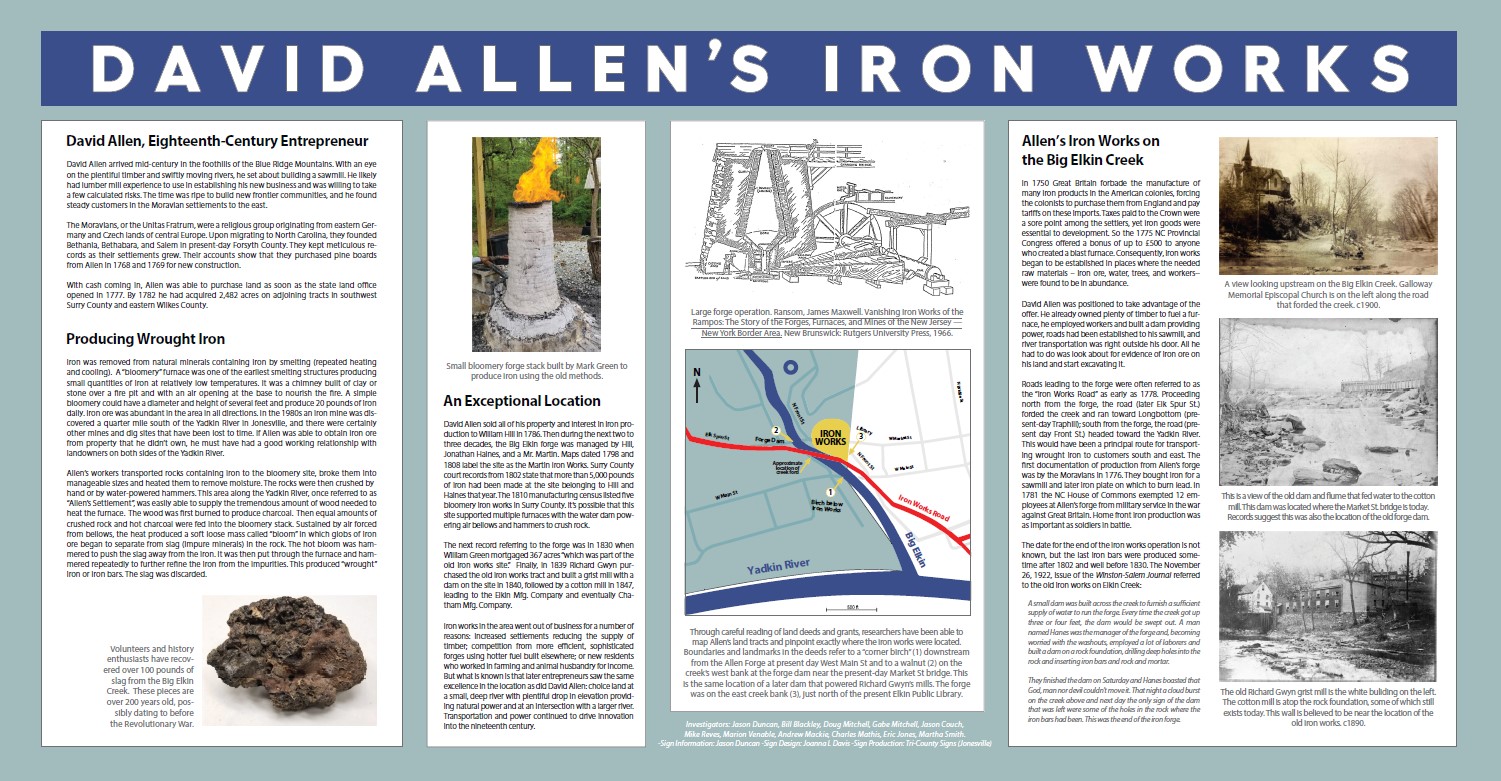
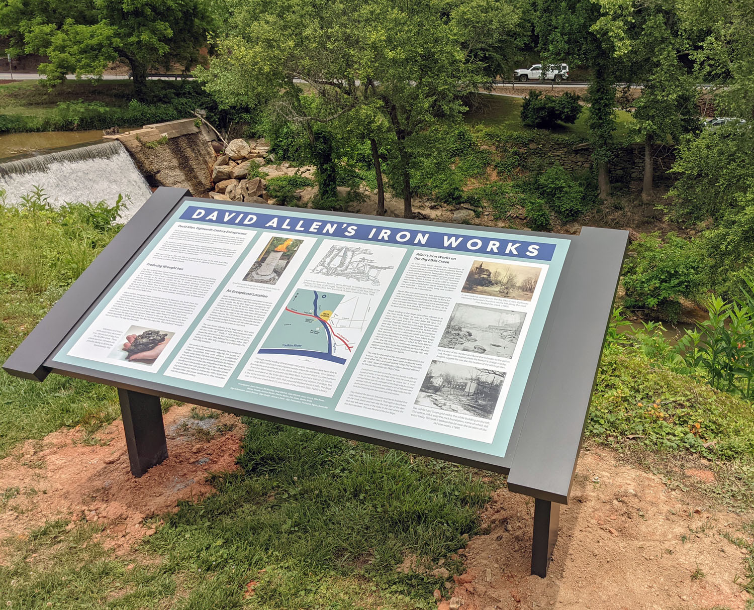
David Allen's Iron Works on the Big Elkin
David Allen arrived in what is now Surry County (then Rowan County) before 1768. He and his family likely came from New Jersey since his son's (David Jr's) Revolutionary pension request states that he was born there about 1760. By 1772 David Allen Sr had started an iron works on the Big Elkin Creek that played a crucial part in the War for Independence. Not only was the operation producing iron for tools and weapons, but it also served as an informal meeting location for troops. David Allen sold the property in 1785, but production at the iron works likely continued into the 1800s under other managers.
Read about Elihu Ayers who provided first-hand knowledge of the iron works in his 1833 Revolutionary War pension request.
If you have questions or comments about David Allen's Iron Works, please contact me.
Presentations
- 9/23/2019 Slide Show Presentation About the Iron Works (pdf)
Shown during the meeting at the library with interested members of the community.
- 3/23/2022 Slide Show Presentation About the Iron Works and how it affected future development in Elkin (pdf)
Shown at the Yadkin Valley Rotary Club.
- Approximate location of the Iron Works
The Iron Works was along east side of the Big Elkin, just south of the Market St bridge near the current dam above the library. (updated 3/17/21)
- Time Line
This is an all-inclusive list of events involving the iron works on the Big Elkin. According to a 1922 history article in the Winston-Salem Journal, the iron works continued operations until a flood washed away the dam. I believe this flood must have occurred sometime after the iron works was shown on a 1798 map, and several years before an 1827 deed referred to it as "Allen's old iron works place". It might have even been before 1809 when a road order also referred to it as "the old iron works".
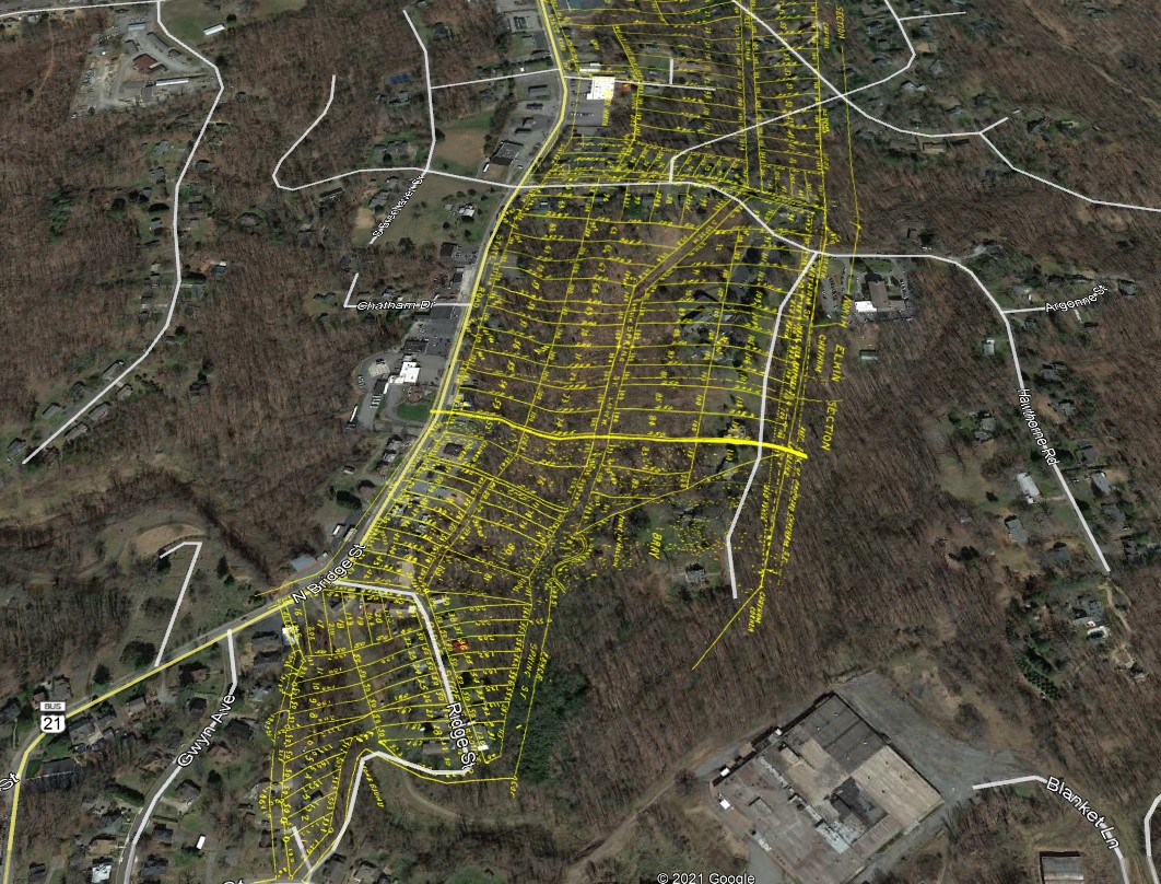
- Map Showing the Iron Works and Land Grants
The map also shows the property originally owned by David Allen. The star marks the location of the iron works near the library.
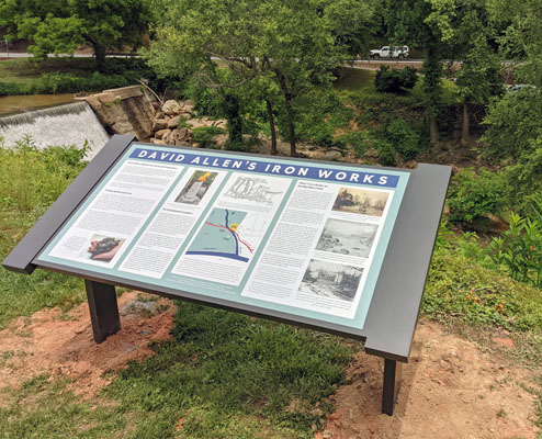
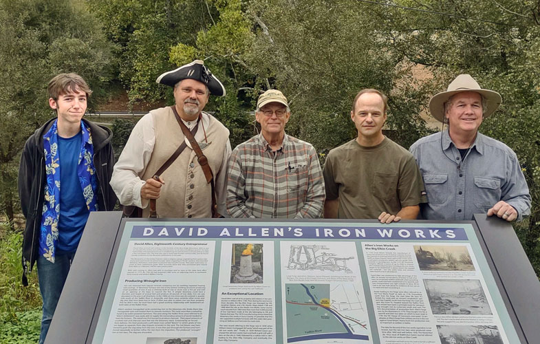
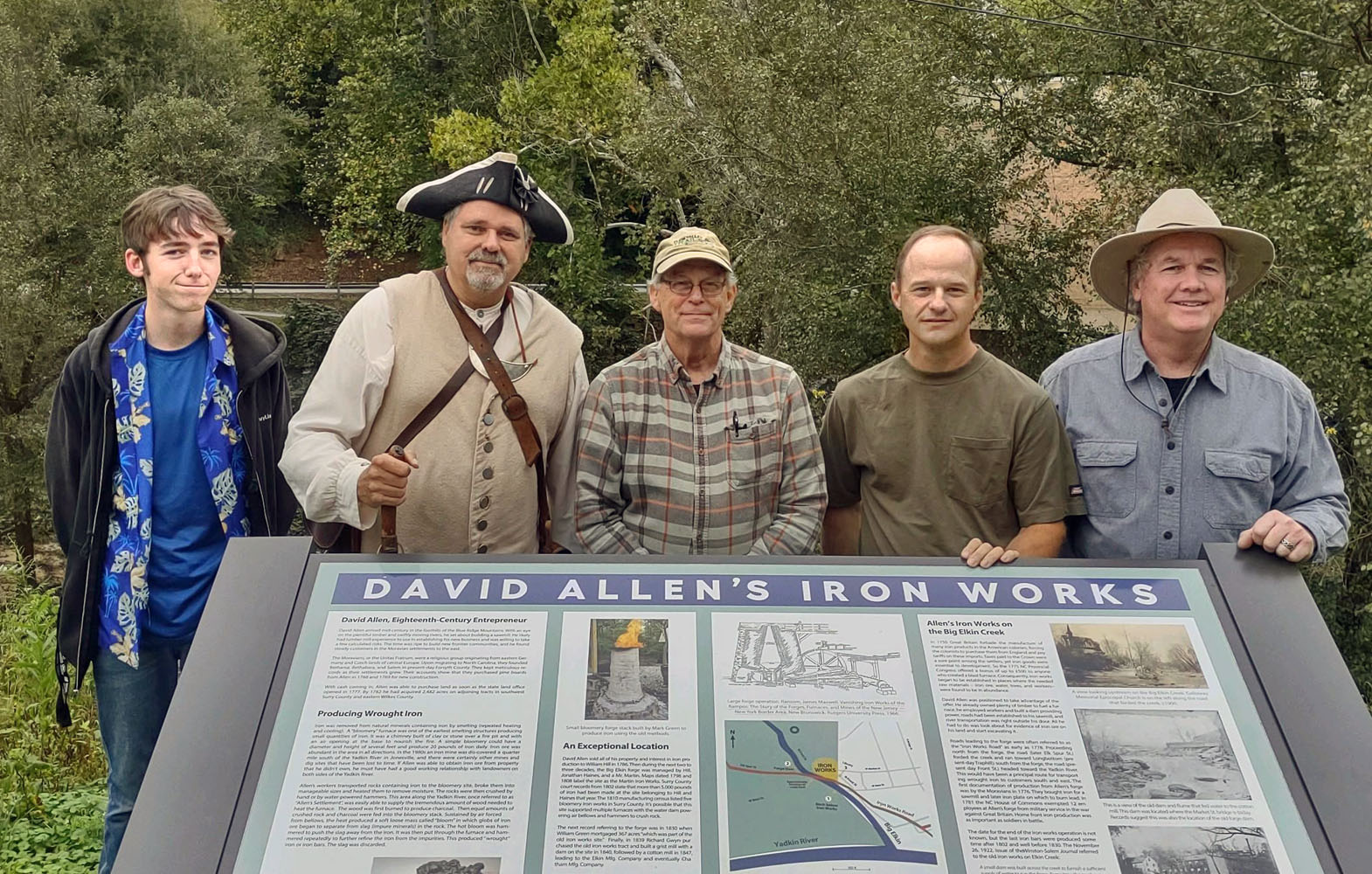
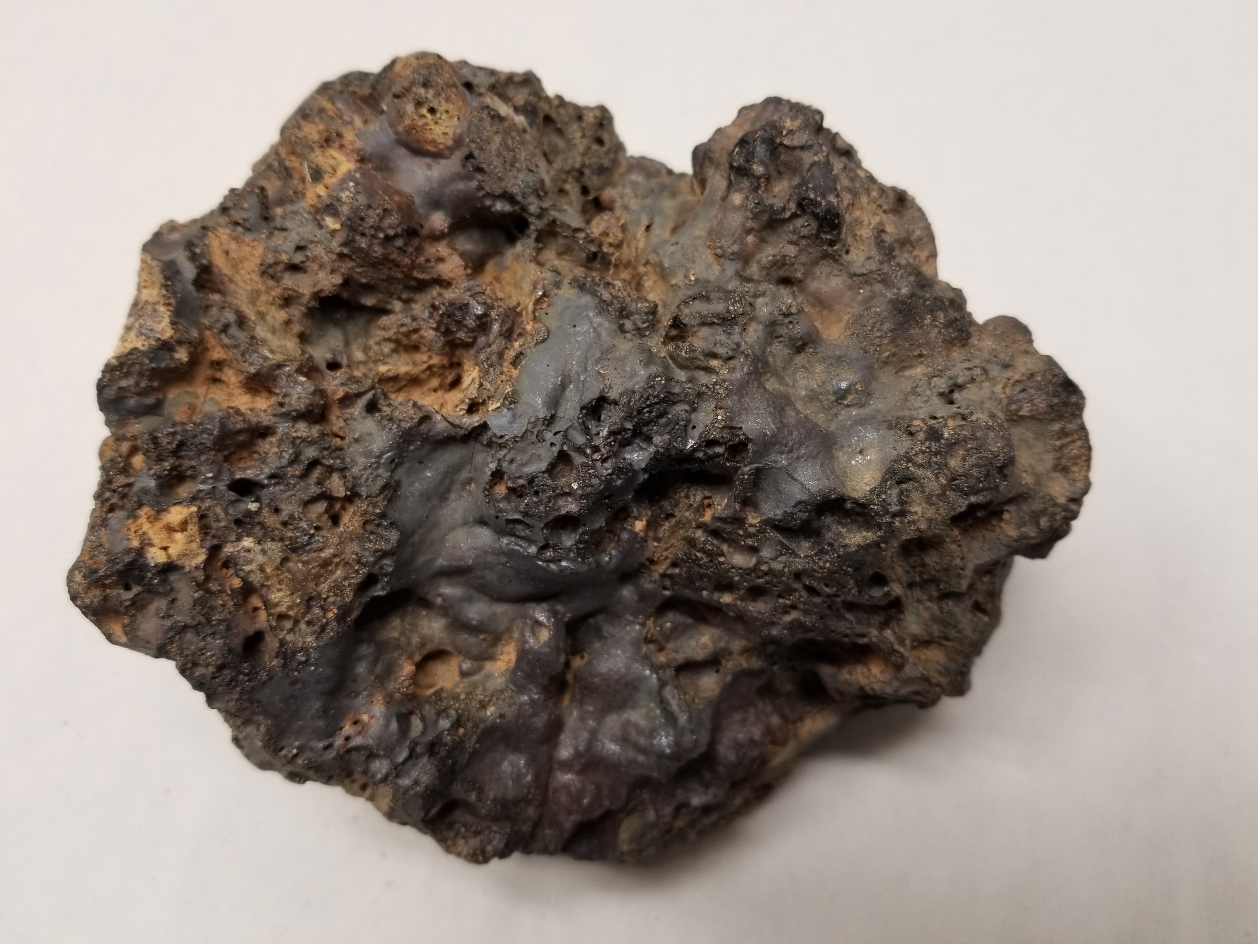
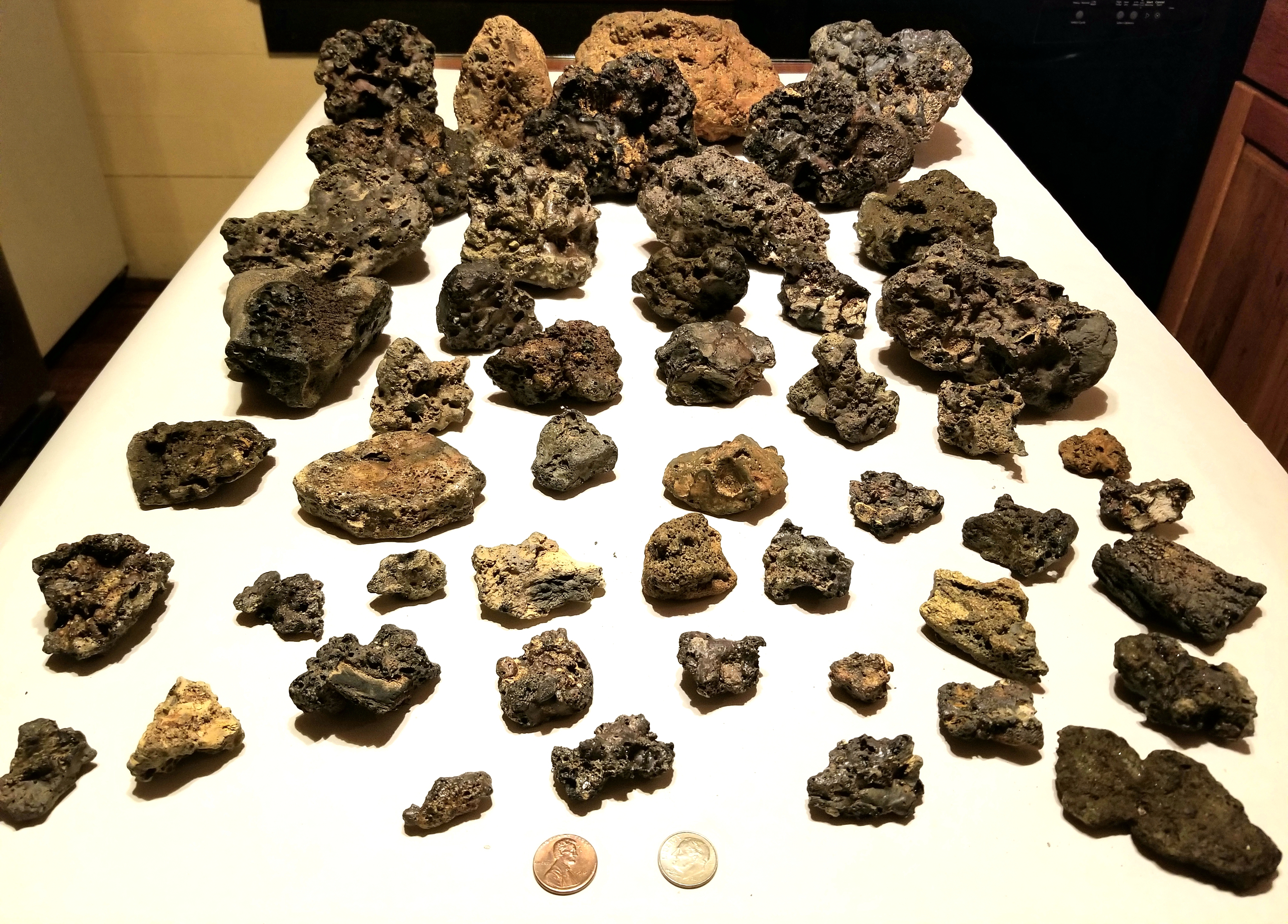
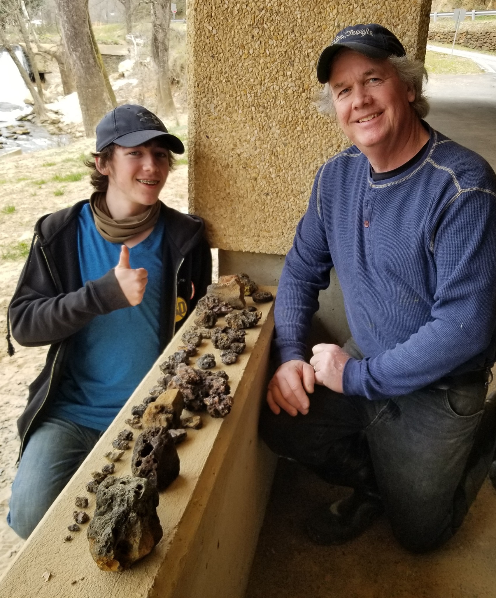
- In June 2021, a historical marker was installed along the Overmountain Victory Trail overlooking the Big Elkin Creek and the site of the Iron Works. Deeds and slag found in the creek suggest that the furnace(s) were located below the dam, near the old rock wall foundation on the east side of the creek.
Pictured: Gabe Mitchell, R. G. Absher, Dr. Bill Blackley, Jason Duncan, Doug Mitchell.
(click to enlarge)
Records
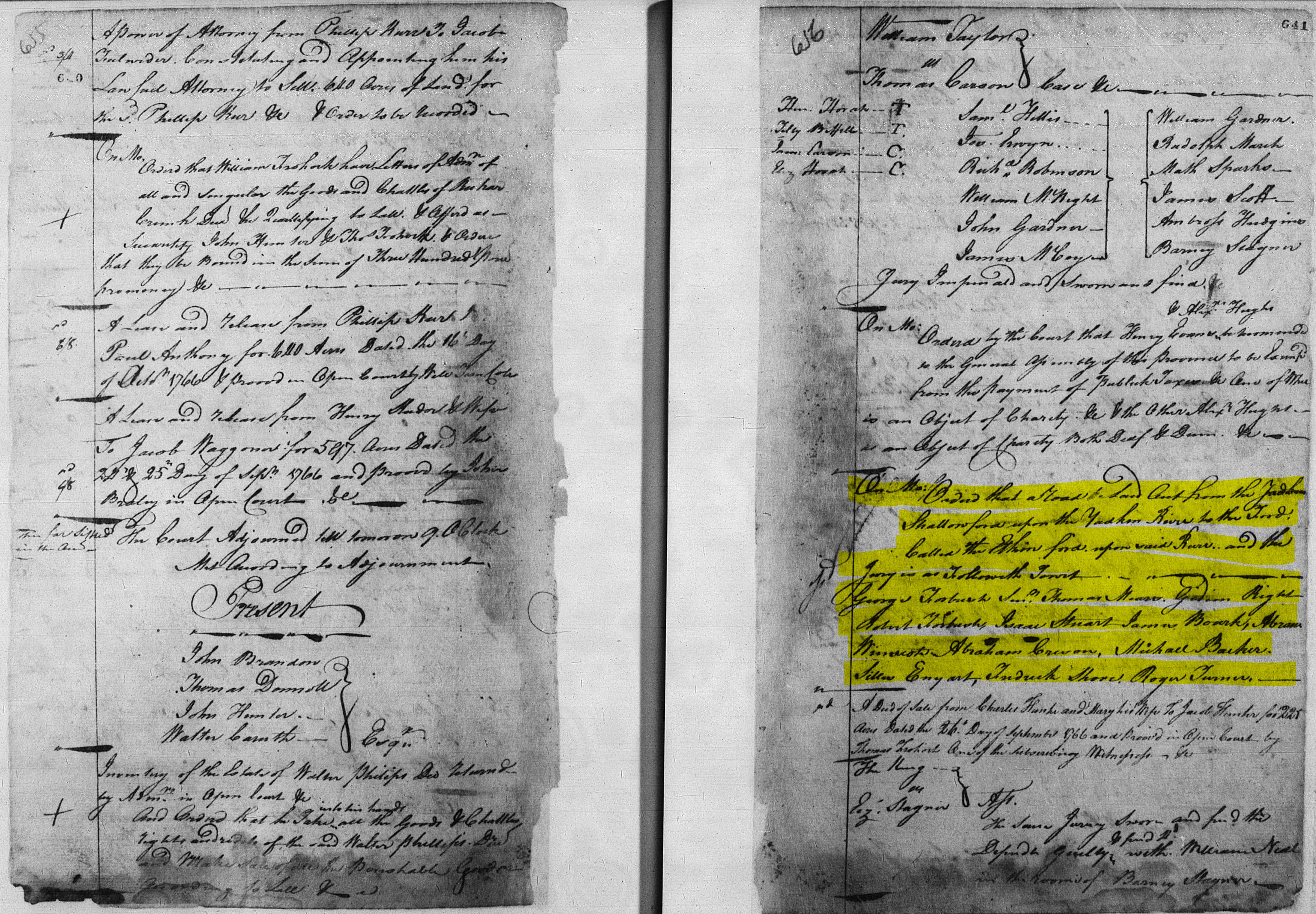
- 1766
- Rowan P&Q Minutes, Vol 2, p656
The Rowan County court minutes on 10/17/1766 includes an order to lay out a road from the Shallowford on the Yadkin to "the ford called the Elkin ford upon said river". This is the earliest mention of "Elkin" found so far. At that time, the word "Elkin" referred to the creek that flows into the Yadkin. The town of Elkin was incorporated over 120 years later in 1889.
- 1768
- David Allen in the Moravian Records (1768-1769)
In 1768 and 1769, the Moravians in Salem were buying lumber from David Allen's saw mill. The boards had been floated down the Yadkin River. This suggests that his first business on the Big Elkin was saw milling. He would soon transition to iron production. This 1768 mention is the earliest record of David Allen in the area, and while it doesn't specifically say he was located on the Big Elkin, he almost certainly was.
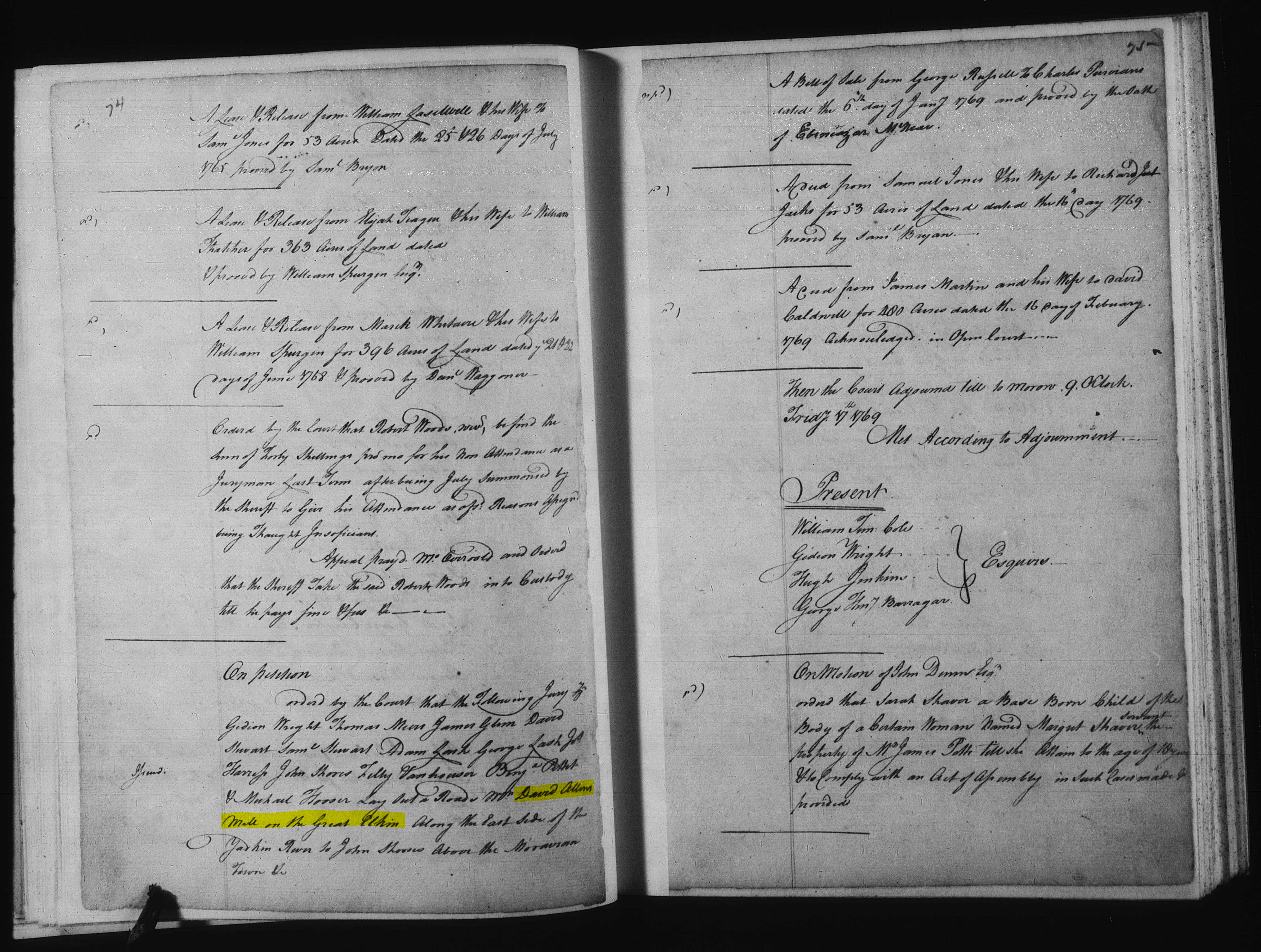
- 1769
- 1769 Rowan Co P&Q Minutes Vol 3, p75
On 2/16/1769, Rowan Co court records refer to a road being laid out from David Allen's mill on the Great Elkin, running along the east side of the Yadkin River to the Moravians. Perhaps this road roughly followed Hwy 268. This is the earliest record of David Allen on the Big Elkin. There's no mention of the iron works, so perhaps this was when he was still in the saw mill business, soon before he transitioned to iron production.
- 1772
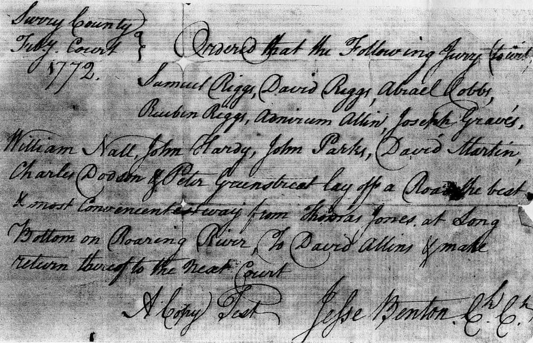
- 1772 road order
February 1772 court order to lay out a road from Thomas Jones (Joines?) at Long Bottom on Roaring River to David Allen's. This would be the route of the old Elk Spur Rd which became Austin-Traphill Rd. The lower portion of this road is still called Elk Spur St. (Unknown source. This record must be from either Surry or Rowan County.)
- Diary of Rev. George Soelle
In Records of the Moravians in North Carolina by Adelaide Fries (page 789-794), there is a section on Rev. George Soelle who traveled through the Yadkin River area in the 1760s and 1770s. He kept a diary of his travels between 1771 and 1773. In September 1772 he wrote about passing through the Fox Nobbs to the home of "old Swim" (perhaps Swaim?) at the foot of the mountains. Fox Knob is now called Star Peak at the south end of Jonesville. From there, he went to Pipe's house in Allen's Settlement. In 1778, John Pipes entered land on the south side of the Yadkin River on Pipes Creek (now Lineberry Creek) east of Jonesville, and perhaps this is where Soelle visited on his trip. The fact that Soelle called the area "Allen's Settlement" is an indication that David Allen's operation was the hub of this growing community. Perhaps more details about these locations are contained in the actual diary which is in the Moravian Archives in Winston-Salem.
- 1773
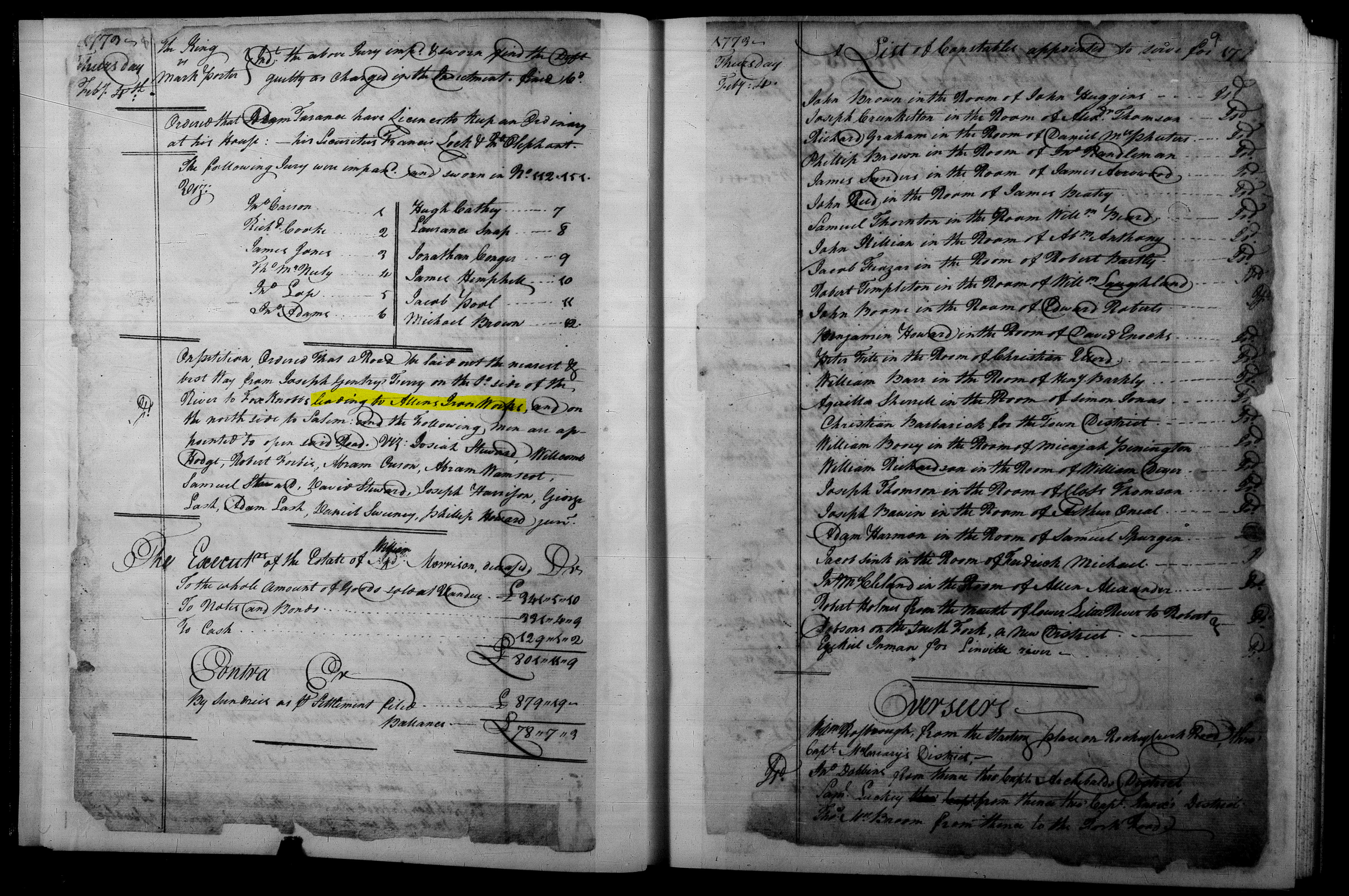
- 1773 Rowan Co P&Q Minutes Vol 4, p8
On 2/4/1773, Rowan Co court records refer to a road on the south side of Fox Knob (now Yadkin Co). This road intersected a road that led to Allen's Iron Works. This is the earliest mention of the iron works on the Big Elkin.
- 1778
- 1778 Surry Grant #50 (file #52) to David Allen (Grant 1 of 5)
On 6/9/1778, David Allen entered 5 acres that included "a certain iron mine pit". This meant that he requested to buy this land from the state, and on 9/20/1779 the grant was issued to him. This was the first of his five land grants. It's not known where this tract was located, only that it was in Surry County which included Yadkin County at the time. It's possible that this land was on the south side of the Yadkin River where an old mine was discovered in 1989 in Jonesville on W. Main St.
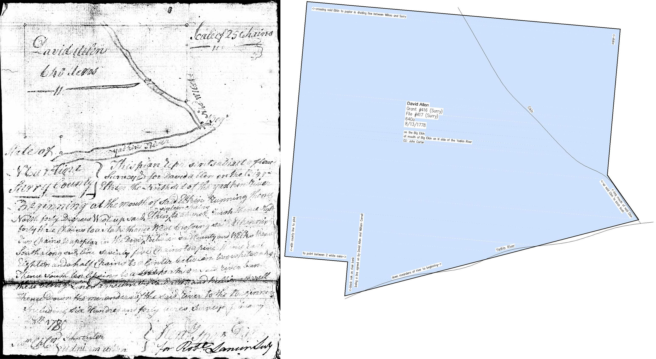
- 1778 Surry Grant #416 (file #417) to David Allen (Grant 2 of 5)
On 8/13/1778, David Allen entered 640 acres on the Big Elkin, and on 10/24/1782 the grant was issued to him. It bordered the Yadkin River on the south and the Wilkes County line on the west. It included all of what is now the Elkin Park. In later deeds, it was known as the "Iron Works Tract". (view map)
- 1778 land entry to Reuben Shores
On 5/28/1778, Reuben Shores entered 350 acres on the south side of the Yadkin River near Allen's Iron Works. The northeast corner of the tract is where the Gwyn-McNeil Bridge now crosses the river. In 1778, this was where the river was forded, and the road was labeled as the "Iron Work Road" on the sketch.
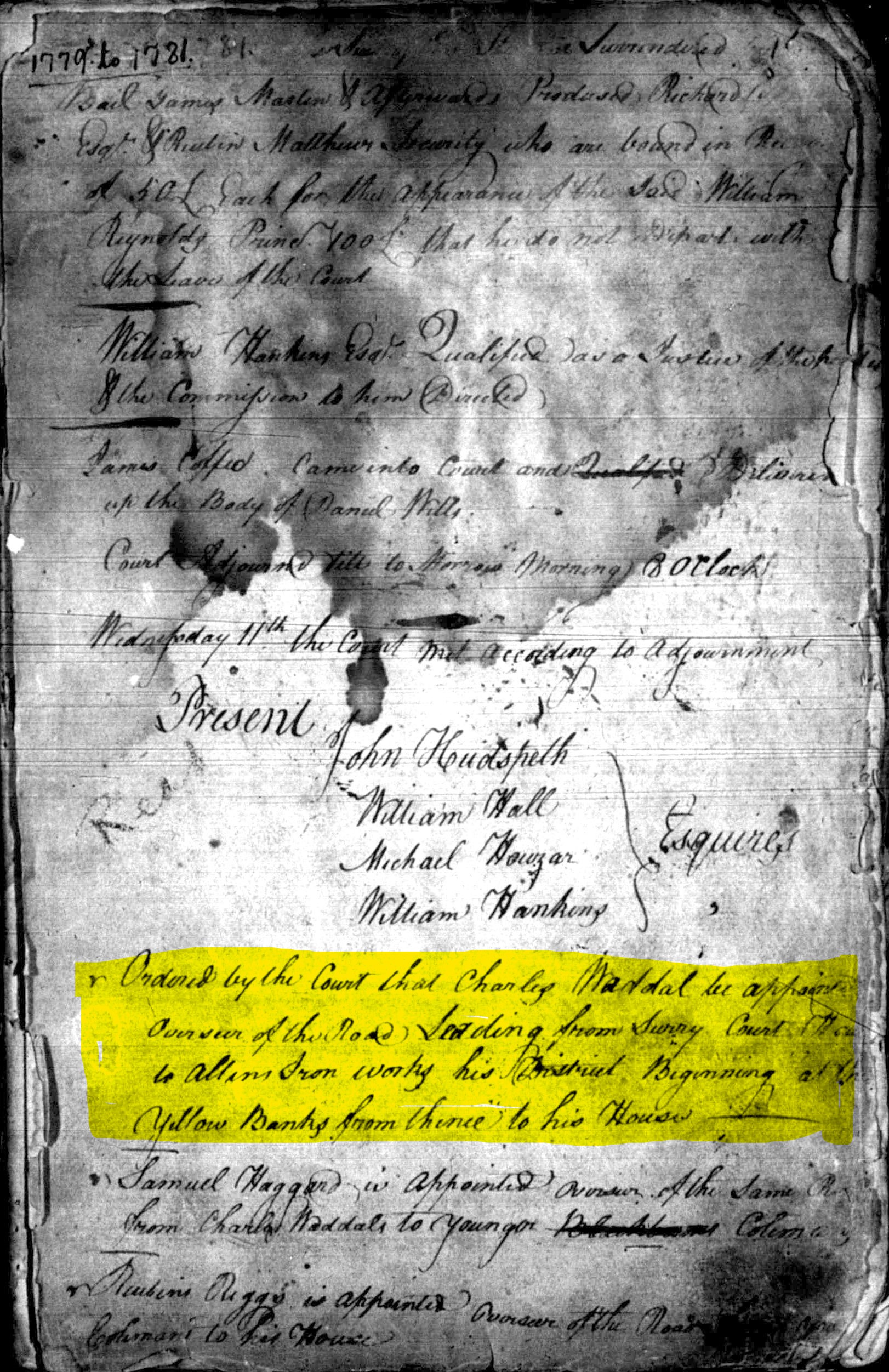
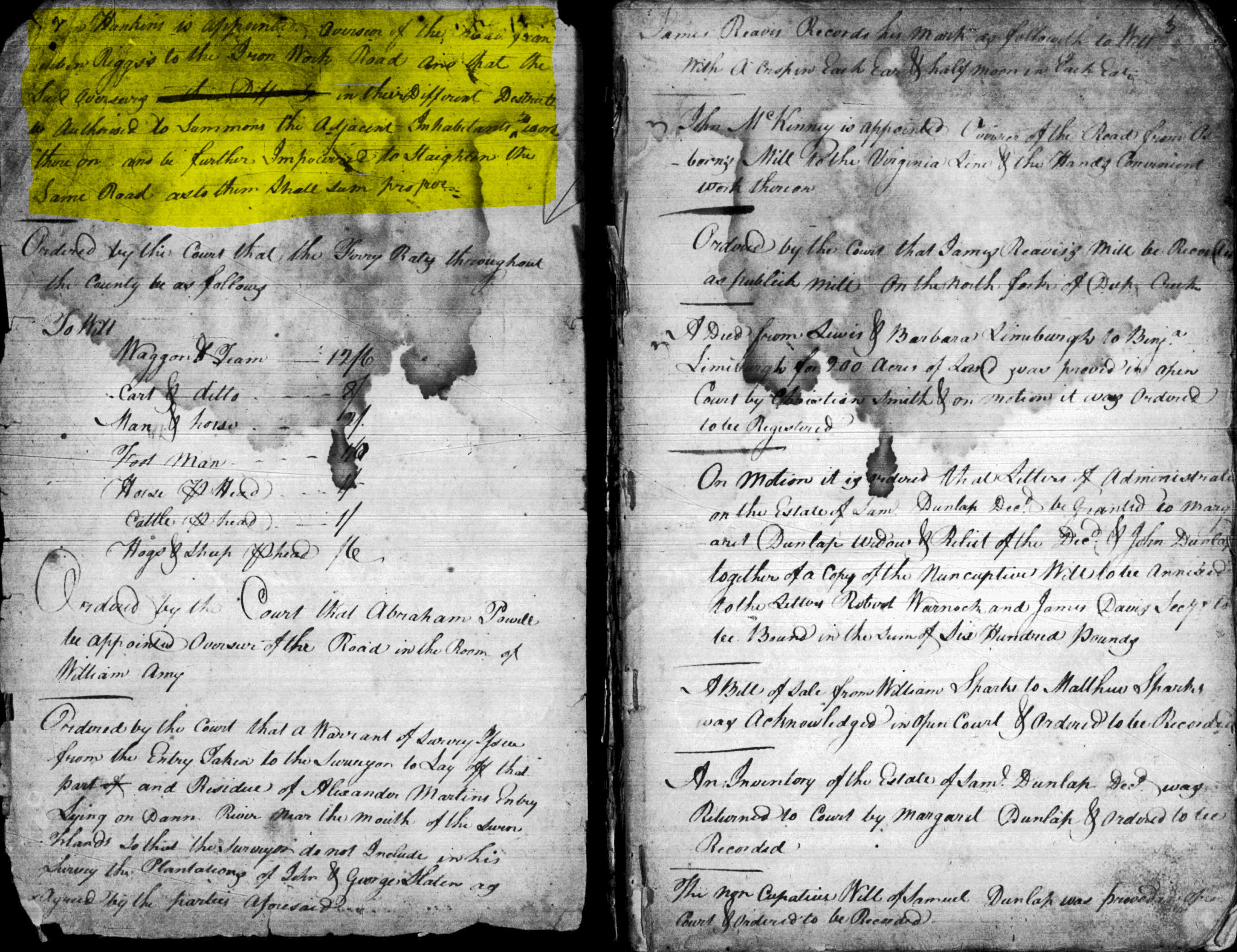
- 1778 road to the iron works
On 11/11/1778, the Surry court ordered that a road be layed out from Surry Court House to Allen's Iron Works. (page 1)
- 1778 road to the iron works
On 11/11/1778, the Surry court ordered that a road be layed out from Reuben Riggs' to the Iron Works Road. (page 2)
- 1780
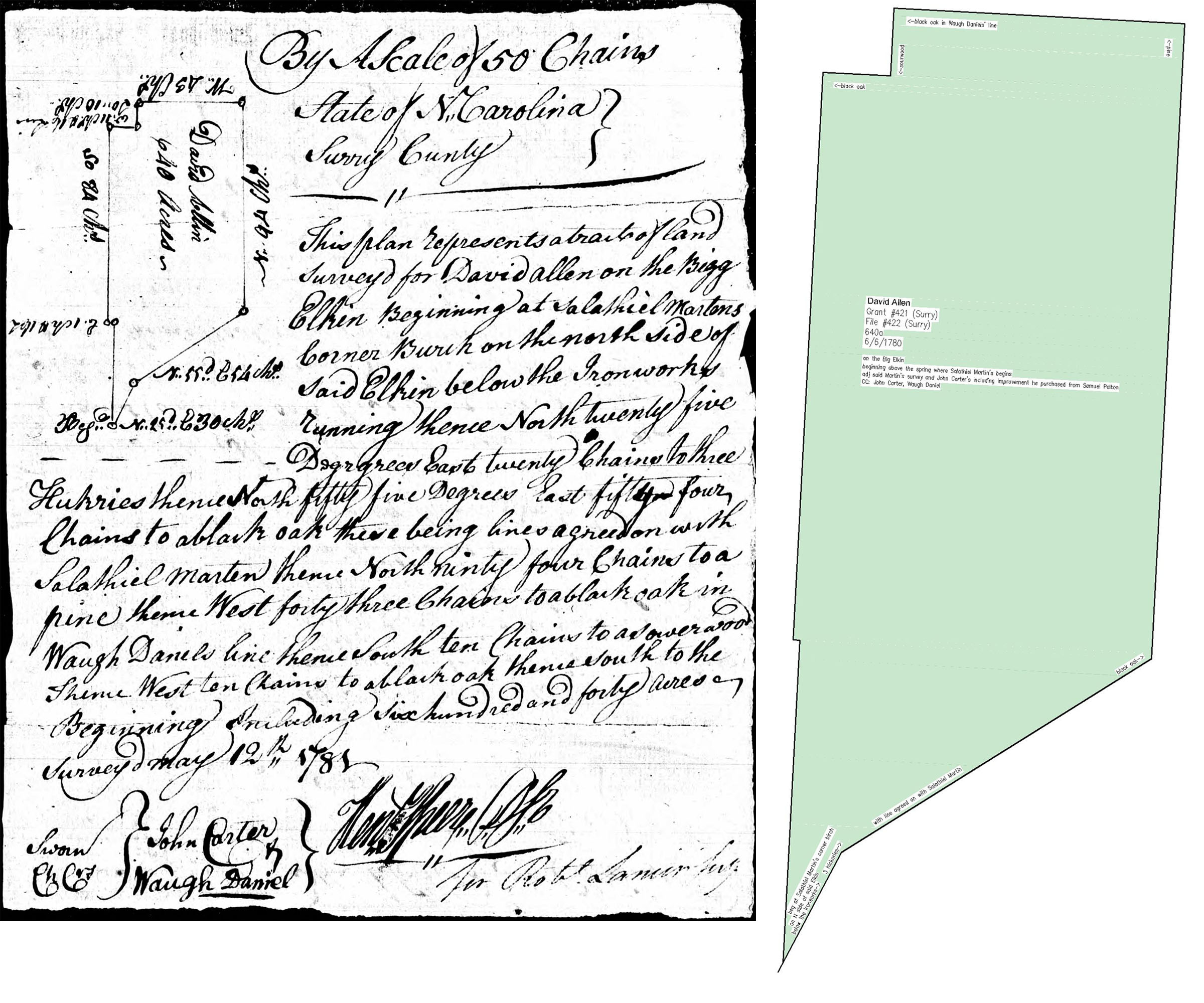
- 1780 Surry Grant #421 (file #422) to David Allen (Grant 3 of 5)
On 6/6/1780, David Allen entered 640 acres on the east side of the Big Elkin, and on 10/24/1782 the grant was issued to him. It included Gwyn Ave, and it went as far north as Claremont Dr where it crosses N. Bridge St. (view map)
- David Allen in the Moravian Records (1780)
In late 1780, the Moravian records mention that "elder Allen was in very bad case" and that their doctor came to Bethania "to dress the wounds of the older Allen". He left their care on 12/7/1780 when one of his sons took him home in a wagon.
- 1781
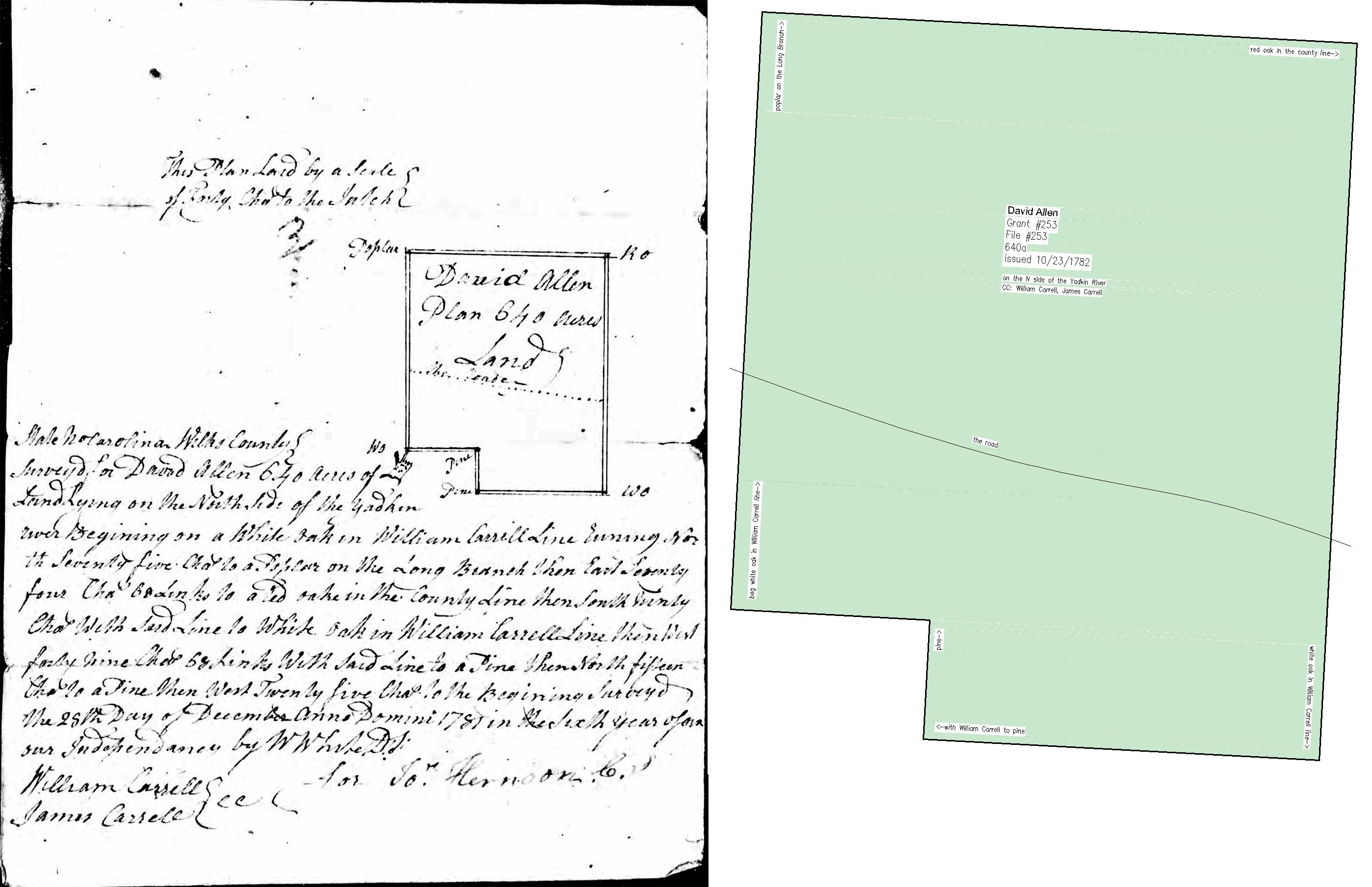
- 1781 Wilkes Grant #253 (file #253) to David Allen (Grant 4 of 5)
On 4/4/1781, David Allen entered 640 acres in Wilkes County which bordered his land in Surry County. The grant was issued to him on 10/23/1782, and this was the fourth of his five grants. This tract stretched west from the county line along Austin-Traphill Rd as far as the Pleasant Hill Fire Department. Deeds in the late 1800s refer to "an old mine hole" which was located at the northern end of this tract. (view map)
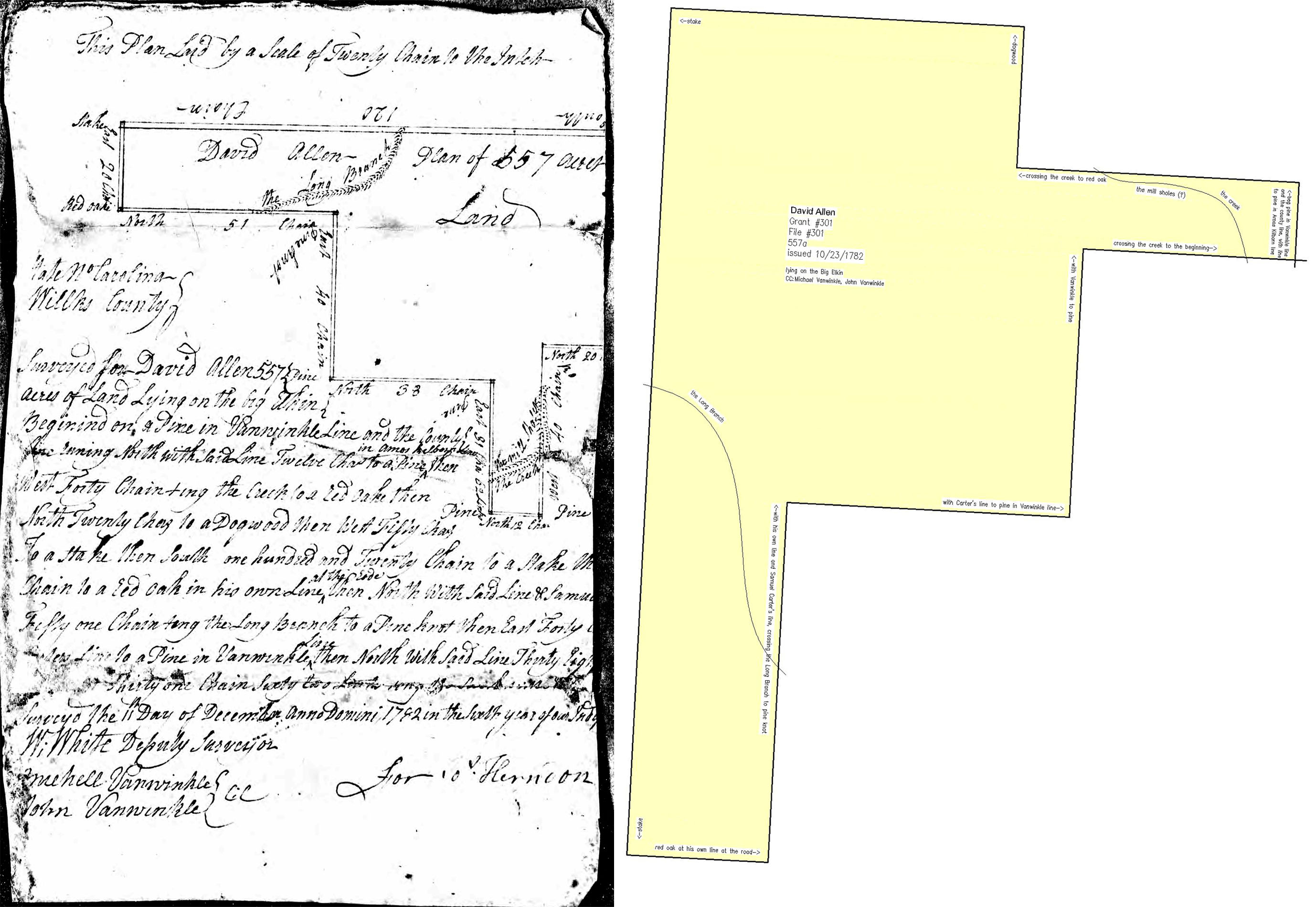
- 1781 Wilkes Grant #301 (file #301) to David Allen (Grant 5 of 5)
On 4/4/1781, David Allen entered 557 acres in Wilkes County on the north side of his other Wilkes tract. The grant was issued to him on 10/23/1782, making the total of his five land grants 2,482 acres. This tract stretched north along CB Eller School Rd as far as Carter Mill Rd. (view map)
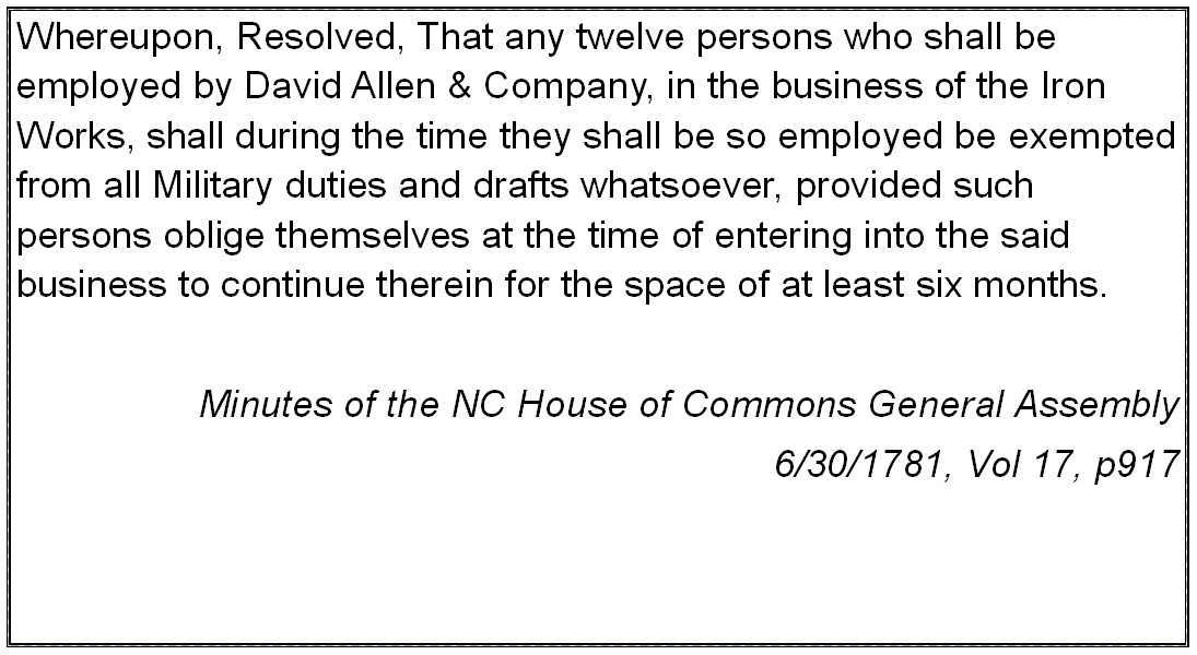
- 6/30/1781 Minutes of NC House of Commons (Vol 17, p917)
The House of Commons declared that up to twelve employees of the David Allen Iron Works would be exempt from military duties as long as they work for six months.
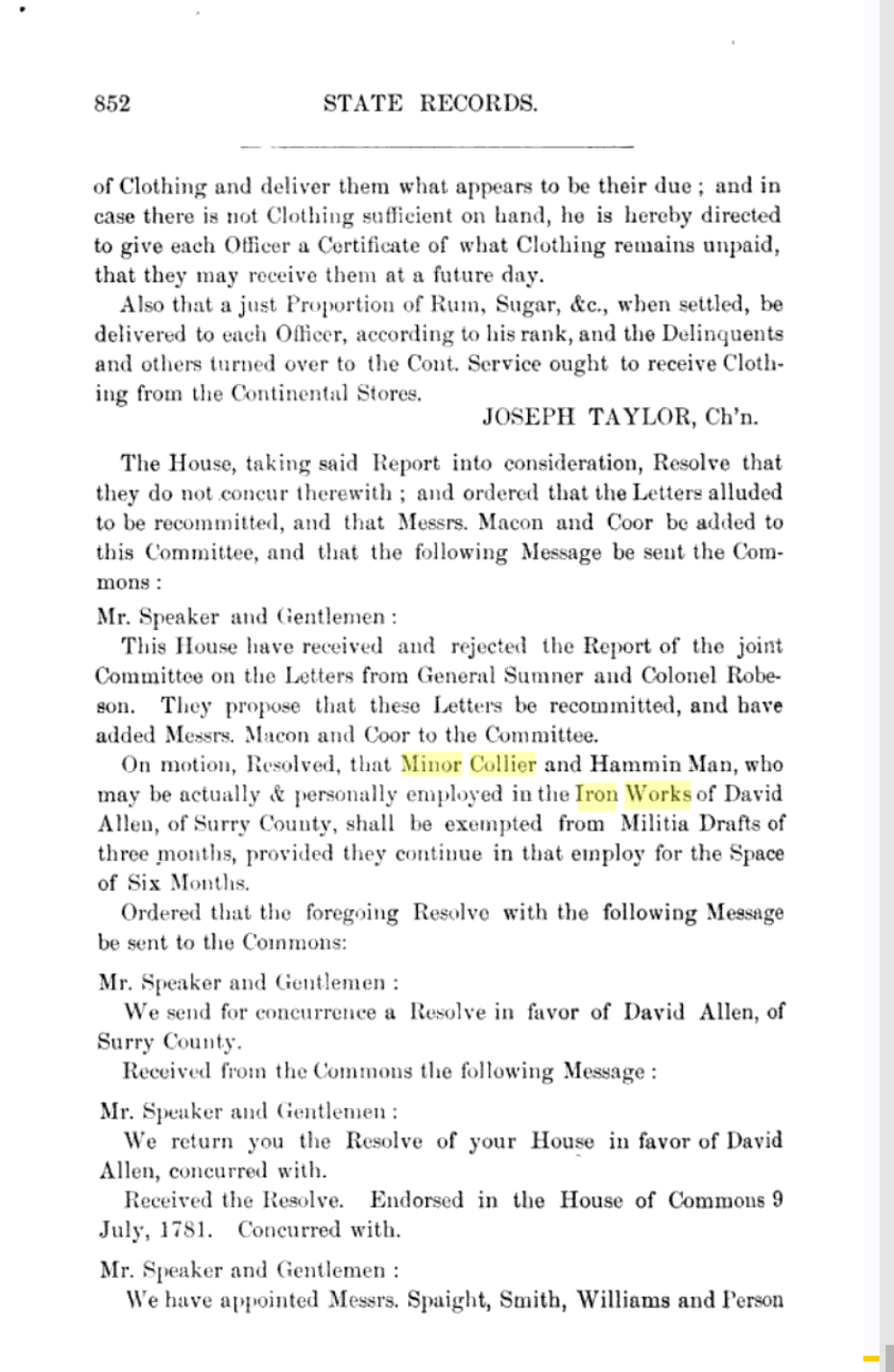
- 7/9/1781 Minutes of NC House of Commons (Vol 17)
The House of Commons declared that two men who were employed in the Iron Works of David Allen of Surry County shall be exempt from militia drafts for three months on the condition that they continue working for six months. The men were Minor Collier and Hammin Man. Since this originally a handwritten document, perhaps the second man's name was Hammond Mann. [I wonder who they were? Why were they singled out by name?]
- 1783
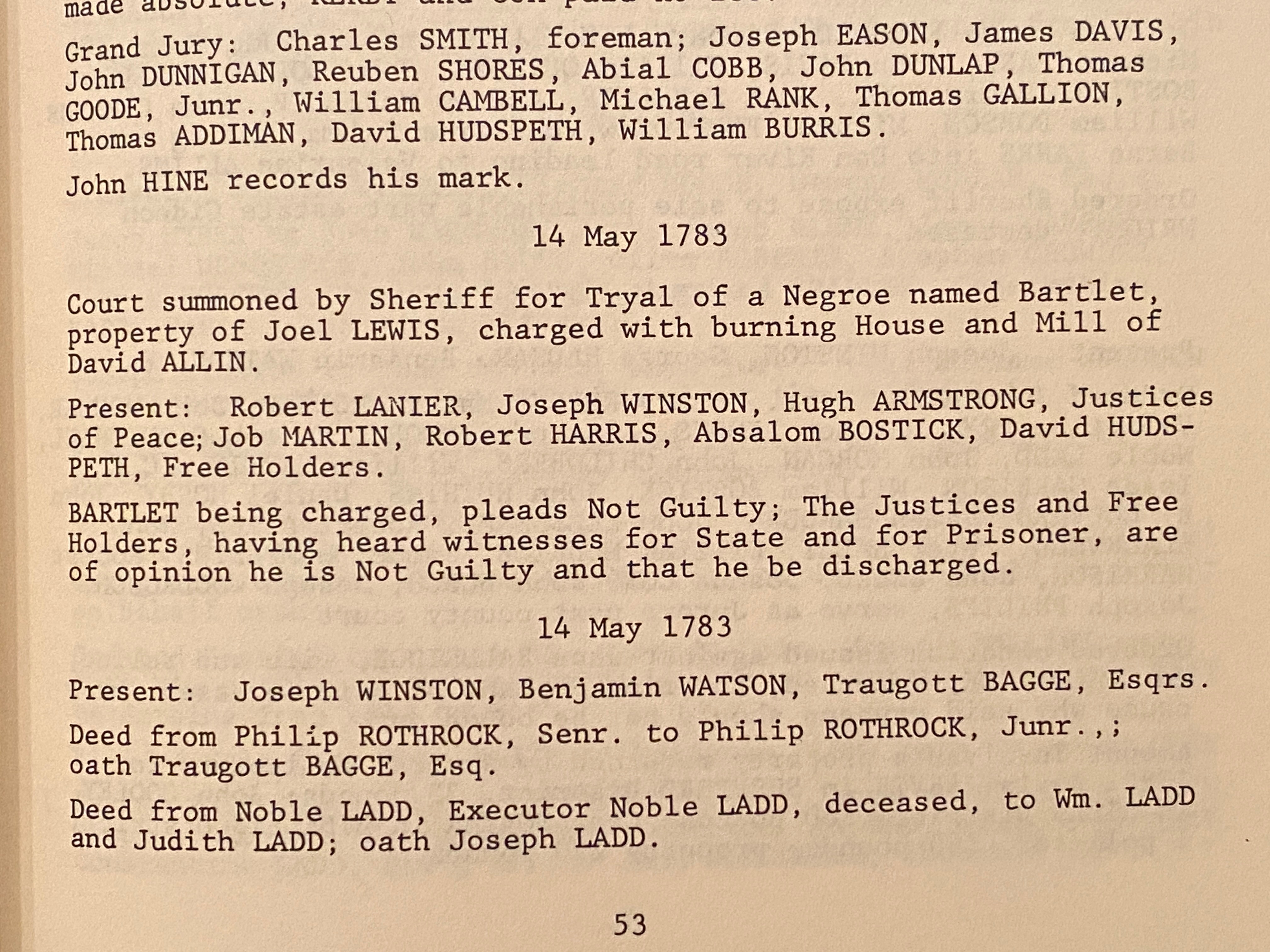
- 5/14/1783 Surry P&Q Minutes
Bartlet, the slave of Joel Lewis was charged with burning the house and mill of David Allen. Bartlet pled not guilty, and the jury found him not guilty. Joel Lewis was the northern neighbor of David Allen. Their property line met on the north side of Elkin Presbyterian Church where Hwy 268 crosses the Big Elkin Creek. Their shared line extended west along Hwy 268 to the Wilkes County line.
- 1785
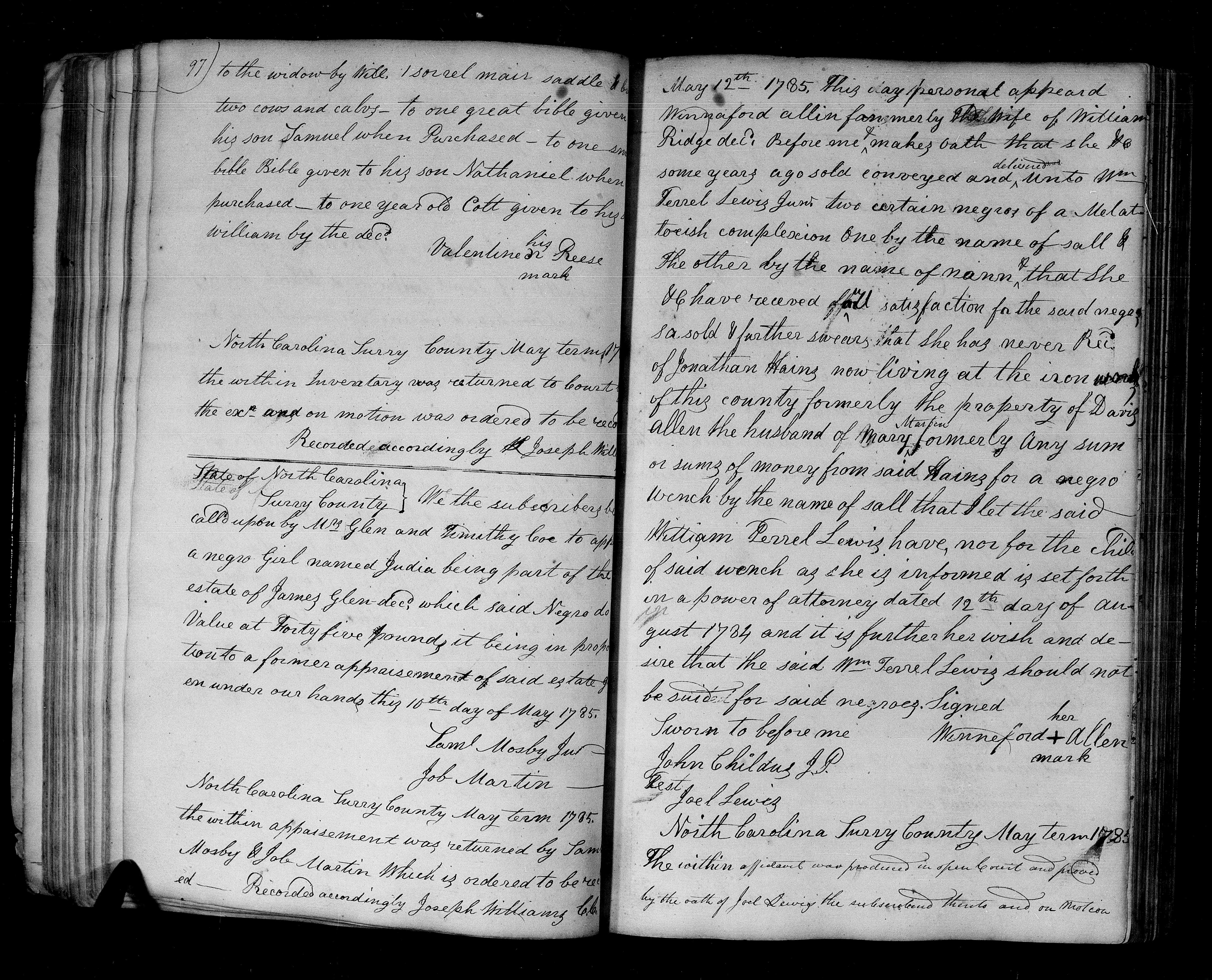
- Surry Will Book 2, p97
1785 court appearance by Winnifred Allen naming Jonathan Hains as "now living at the iron works of this county formerly the property of David Allen". Winnifred Combs (c1749-c1791) first married William Ridge who died in 1780 at the Battle of Hanging Rock, SC. They had several children. By 1783, she had remarried to Nathan Allen. He left her about 1792. It's unknown if Nathan Allen was related to the David Allen who started the iron works.
Without punctuation, the document is confusing where it mentions David Allen. Jonathan Haines was the second husband of Mary Martin, widow of David Martin. David and Mary were the parents of Obediah Martin (b1761) and Salathiel Martin (b1763). This document does not suggest that our David Allen was related to the Haines or Martin families.
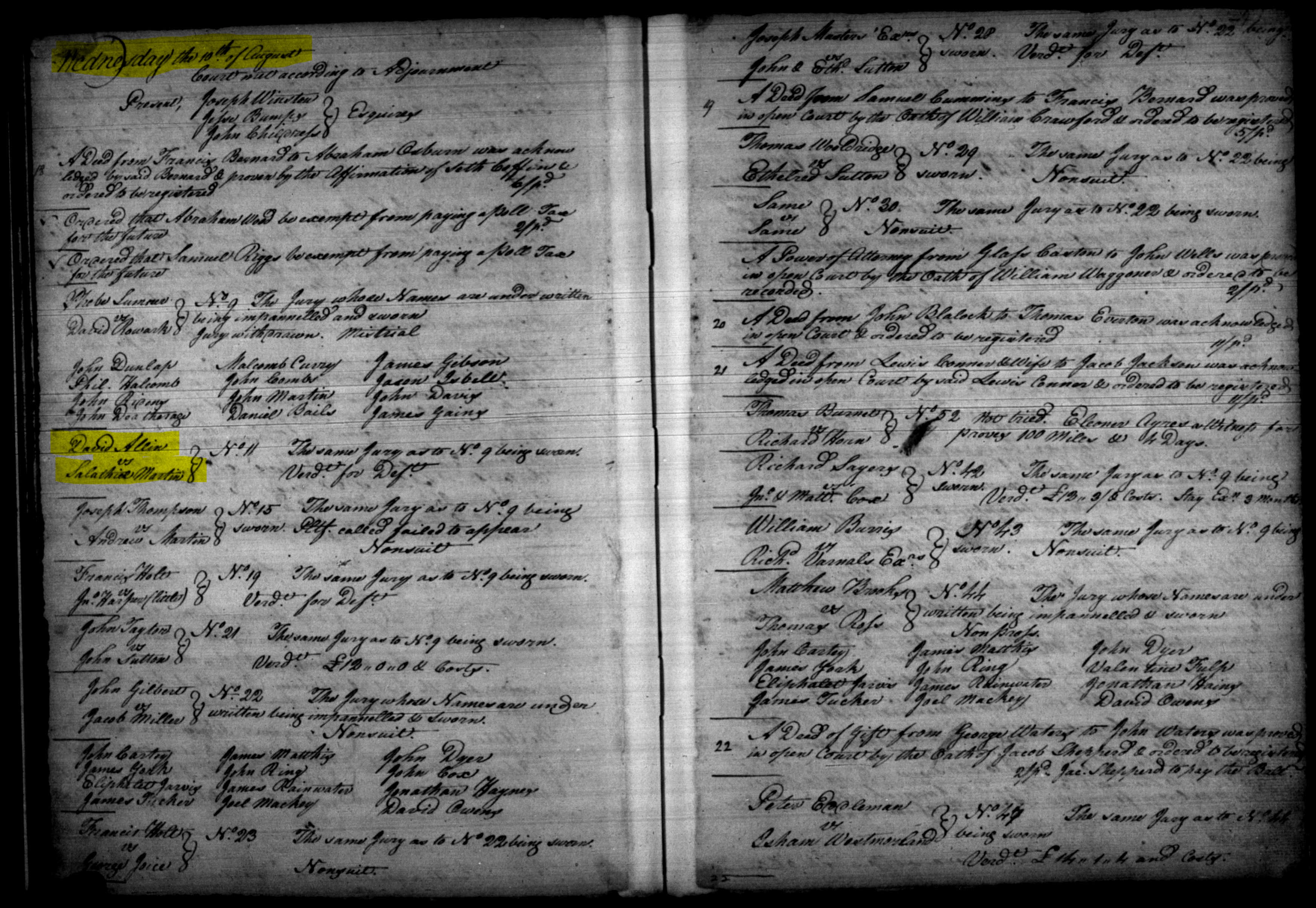
- 1785 Surry County Court Minutes, David Allen vs Salathiel Martin
On 8/10/1785, the Surry court records list a case between David Allen and Salathiel Martin. It's unknown what the case was about. In 1798, a map labeled the iron works location as "Martin's I. W.".
- 1786
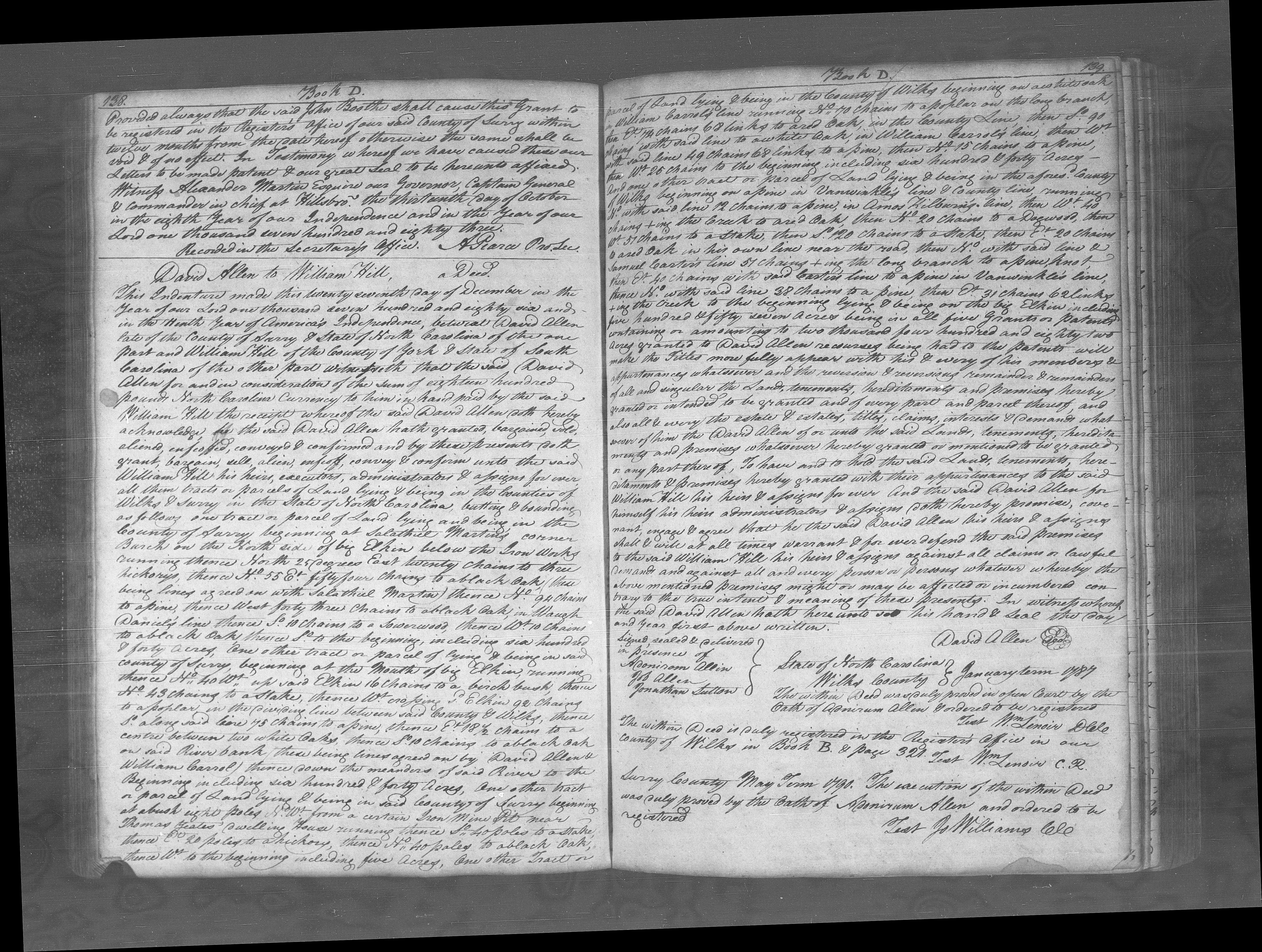
- 1786 deed from David Allen to William Hill
On 12/27/1786, David Allen sold all 2,482 acres of his land to William Hill. This was comprised entirely of the five land grants he purchased between 1778 and 1782. This is the last record of David Allen. He might have lived the rest of his life near the Big Elkin, or he might have moved to Georgia or Tennessee to live with one of his sons.
- 1788
- 1788 NC State Law
1788 NC law statute granting tax-free land to those who erect and successfully run an iron works operation. In 1802, Surry County Court reported that there had been at least 5,000 lbs of iron made at the old Iron Works belonging to Hill and Haines on the Big Elkin. It was therefore ordered that warrants be issued on two entries they had made for additional land. This land was on the east side of Elkin and west of Mitchell River.
- 1798
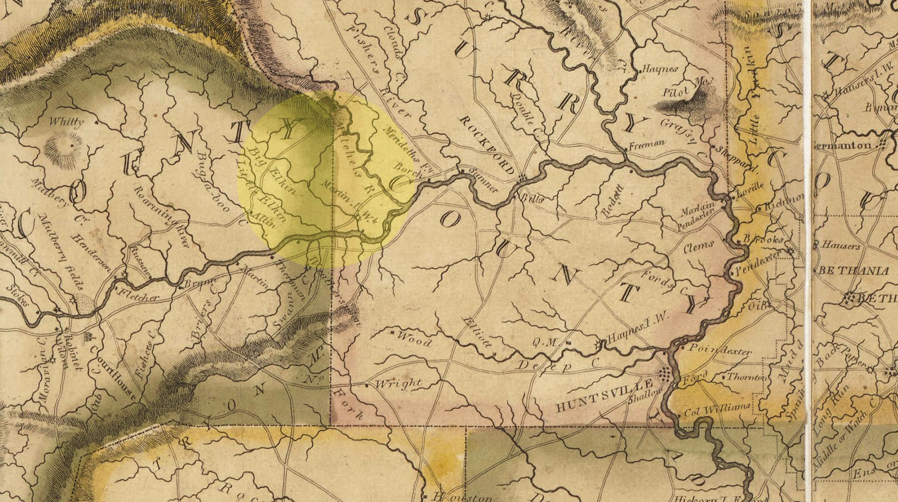
- 1798 NC State map showing Surry County
A 1798 map of NC was produced by Jonathan Price and John Strother. In Surry County, the "Martin I.W." is shown on the north side of the Yadkin River along the Big Elkin. Perhaps the Iron Works was being managed by Obediah Martin at this time. This map was reissued in 1808 with no differences in the Surry County area. The 1808 version is shown here since it is in better condition.
- 1809
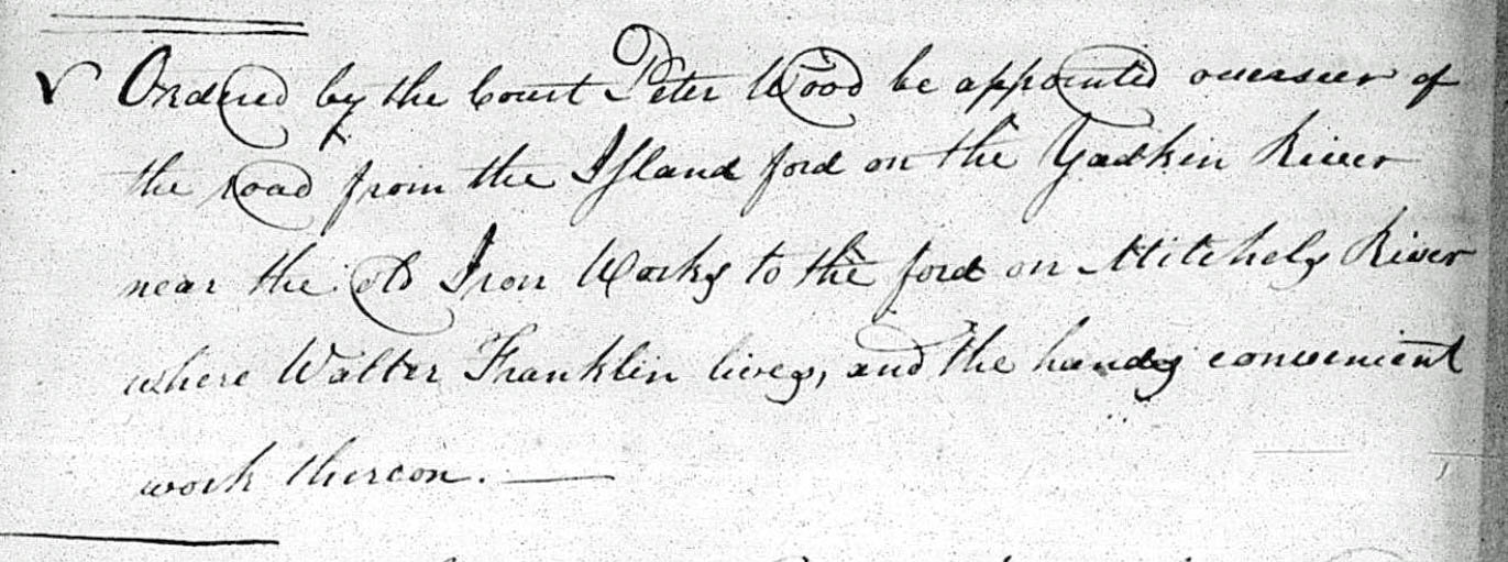
- November 1809 Road Order
"Ordered by the court Peter Wood be appointed overseer of the road from the Island Ford on the Yadkin River near the old Iron Works to the ford on Mitchels River where Walter Franklin lives, and the hands convenient work thereon." By saying "old" Iron Works, that might mean that it was no longer in operation. This seems to be the route of Hwy 268 between the Big Elkin and Mitchells River.
- 1813
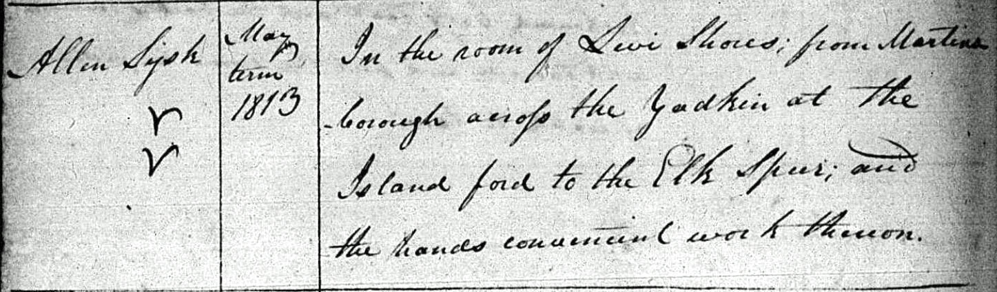
- May 1813 Road Order
"Allen Sysk: In the room of Levi Shores, from Martinsborough across the Yadkin at the Island Ford to the Elk Spur, and the hands convenient work thereon." This would be the route from the Yadkin River, up Front St and continuing up Elk Spur St. The name of Martinsborough was changed to Jonesville in 1811, but the old name was apparently still being used.
- August 1813 Road Order
"Barret L. Martin: In the room of Peter Wood, from the Island Ford on the Yadkin River near the old Iron Works, to the ford on Mitchell's River where Walter Franklin lives, and the hands convenient work thereon." Barret Martin was replacing Peter Wood who was appointed in the 1809 record above.
- 1827
- 1827 deed of trust from Jonathan Haynes to Litle Hickerson
A deed of trust dated 5/15/1827 (Surry DB T, p96-7) suggests that Jonathan Haynes was ordered by the court to pay debts. He was forced to sign over 1,520 acres of land and eleven slaves to Litle Hickerson to secure those debts. That land included both of David Allen's original 640-acre Surry land grants where the iron works was located. One tract was described as "Allen's old iron work place" suggesting that the iron works had been abandoned by this time.
- 1830
- 1830 deed from William Green to Thomas D. Kelly
A deed dated 9/27/1830 (Surry DB U, p35-6) explains that William Green was indebted to several people including Thomas D. Kelly. In response, he mortgaged a tract of land which was described as a portion of the old iron works tract. By 1832, he had not repaid the loan, and his land was sold at auction where Kelly was the highest bidder.
- 1922
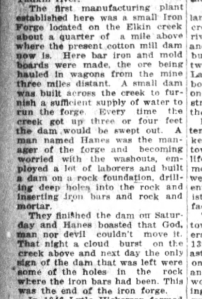
- Freshet Washes Away Dam
This article from the 11/26/1922 issue of the Winston-Salem Journal, page 34, recounts the flood that caused the demise of the iron works on the Big Elkin. Perhaps a review of weather reports between 1808 and 1830 would help determine the year of this flood.
- 2021
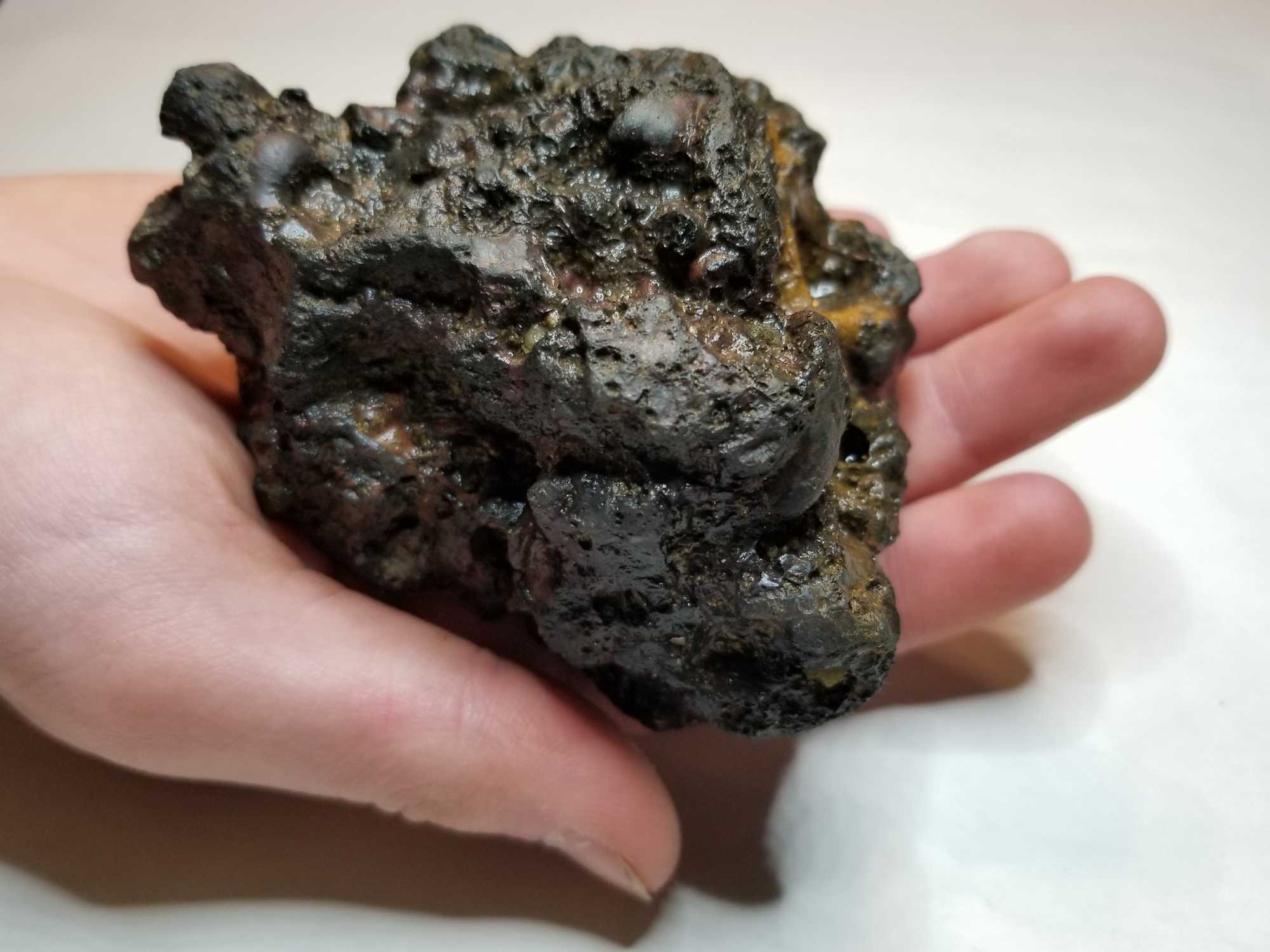
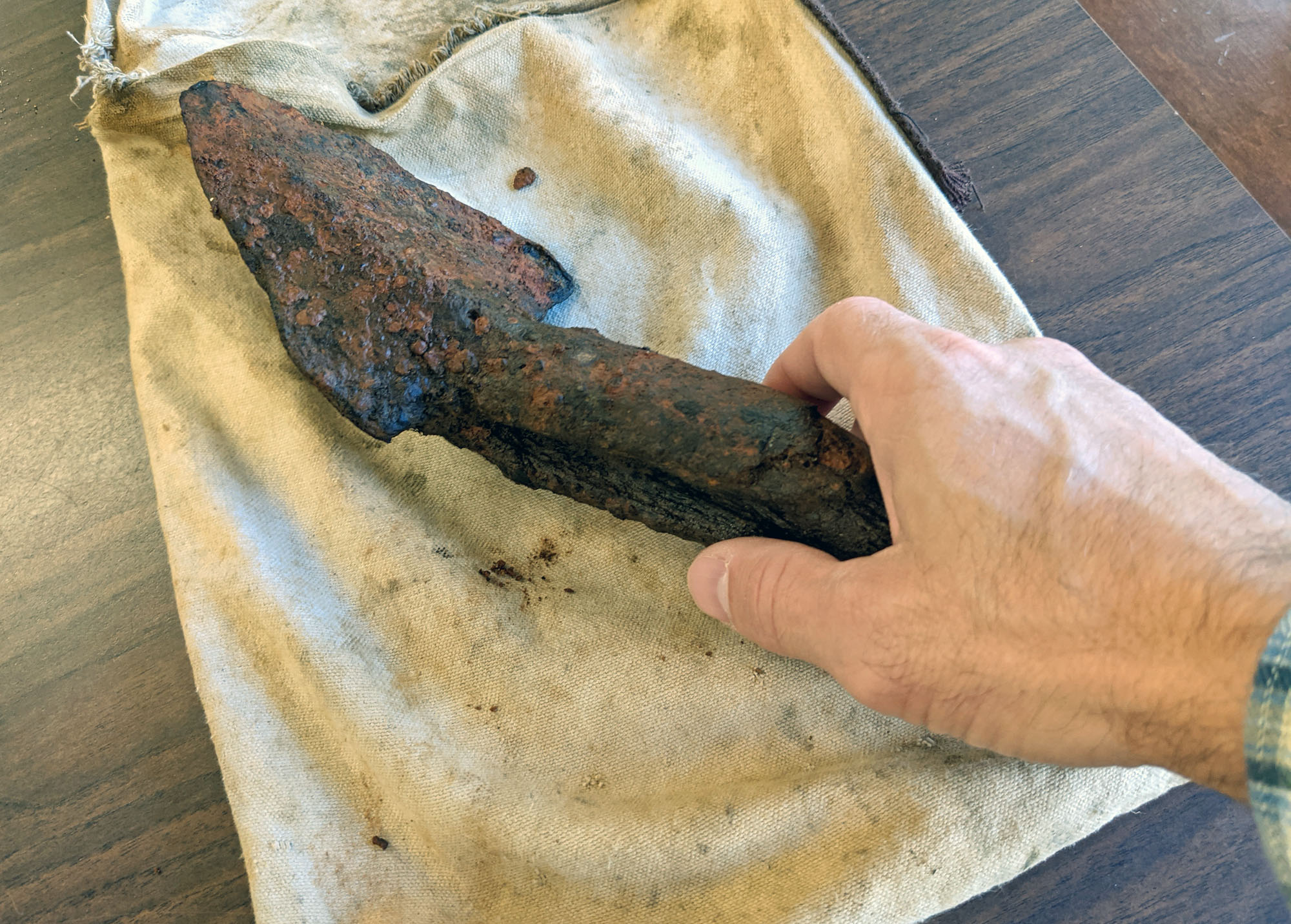
- Tool found onsite. (photo)
Tool and matching slag piece. (Youtube video)
In October 2021, Doug Mitchell found this spade-shaped tool in the Elkin Creek at the site where the forge is believed to have been located. It's about 4" wide and 12" long where the wooden handle is broken. It appears to be two pieces of iron cupped together between the handle, and perhaps it was used to retrieve the iron or clean the inside of the forge. The wooden handle seems to have burn marks near the base. We hope to learn more about it. This tool remained hidden and buried for over 220 years!
Articles and Publications
Old Elkin Photos
Over 200 old photos of Elkin. Use the white filter bar in the 'Description' column to search for a key word or phrase. [Feb 2022]
Maps of Elkin
- Old Elkin Plat Book Maps
(May 2021)
Download the kmz file for the plat book maps, then double-click it to open the file in Google Earth. Each map can be turned on/off independently. It might take 10 seconds or so for some of the larger ones to load. (You'll need Google Earth installed for this to work. It's free.) This is a Google Earth file with 11 Elkin maps from the Register of Deeds office overlaid on today's map. There's also one early map of Jonesville from the late 1800s.
 This is an example of what the overlays look like.
The Elkin maps that were used to generate the Google Earth file are provided below (pdf):
- Plat Bk 1, p41 - 1924 - Hillcrest and N. Bridge
- Plat Bk 1, p17 - 1922 - Hendrix Ave
- Plat Bk 1, p32 - 1922 - Highland Ave
- Plat Bk 1, p47 - 1920s - Veneer St
- Plat Bk 1, p53 - 1924 - Eller St
- Plat Bk 1, p132 - 1929 - Front St
- Plat Bk 1, p138 - 1930 - N. Elkin Dr
- Plat Bk 1, p157 - 1917 - E. Spring St
- Plat Bk 1, p196 - 1939 - Hawthorne
- Plat Bk 1, p197 - 1939 - Spring St Ext
- Plat Bk 1, p204 - 1891 - Downtown
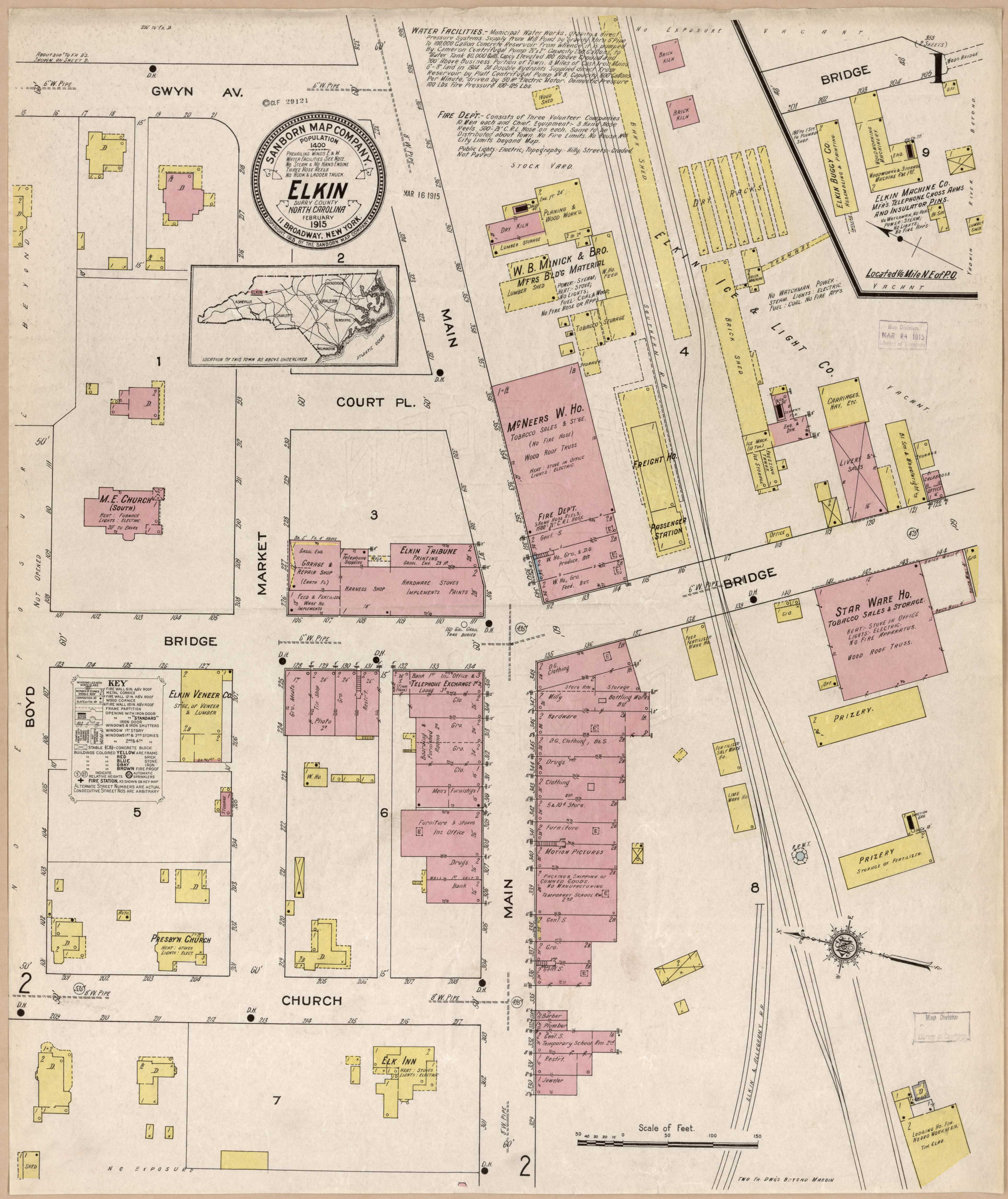
- 1915 Sanborn Insurance Map of Elkin
(May 2021)
Download the kmz file for the Sanborn overlay, then double-click it to open it in Google Earth. It might take a few seconds to load. The Sanborn map was drawn in different segments for industries throughout the town. I cut up those segments and arranged the pieces on the map where they should be located. The Shoe Factory location is approximate at the water treatment plant along the Big Elkin Creek. I feel confident about the location of the rest. Just like the item above, this is a Google Earth overlay file.
These are the two pages of the Sanborn maps that were used to generate the Google Earth file:
- 1915 Elkin Sanborn map page 1
- 1915 Elkin Sanborn map page 2
- Original Land Grants in Elkin
(9/24/19 - [2021: will be updated soon])
This includes the downtown area, much of N. Bridge St, and the area south of CC Camp Rd.
Top of page
Jason Duncan
222 Sundance Cir
Statesville, NC 28625
704-929-2643
jason@webjmd.com
Maintaining a website since April 1995
